Red Canyon, Bryce Canyon
Dry Fork & Cedar Breaks NM
![]() version française
version française
Pictures are small in size and grouped in gallery; just a click on it and you'll have all the gallery in bigger size!
Easy navigation with left or right arrow on the keyboard; leaving the gallery photo by Escape.
Do not forget to switch to full screen (F11). Javascript is required.
Journey map
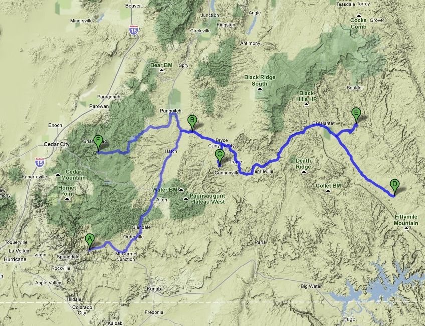
Approximately:
- from Checkerboard Mesa (A) to Red Canyon (B): 60 miles and 1h15 drive on road
- from Red Canyon (B) to Bryce Canyon NP (C): 17 miles and 30 mn drive on road
- from Bryce Canyon NP (C) to Dry Fork (D): 85 miles and 3h drive on road/dirt road
- from Dry Fork (D) to Escalante River (E): 36 miles and 2h drive on road/dirt road
- from Escalante River (E) to Cedar Breaks NM (F): 113 miles and 2h20 mn drive on road
Sunday, June 14 ... (continued)
As we explained earlier (Tuesday, June 9), the loss of our pictures on the laptop and doubt about their recovery have forced us to slightly modify
our trip and repeat a few points where we can't go back home without pictures.
This is the subject of this page, with a return at Red Canyon, Bryce Canyon, Spooky Gulch on the Hole In The Rock Road, Escalante River petroglyphs,
but we'll go through these places very quickly, only concerned with a new crop of photos.
[But, like anything can go wrong, I will not keep mine wanting to go too fast (loss of photos of Zion, Red Canyon and a part of Bryce, see below)]
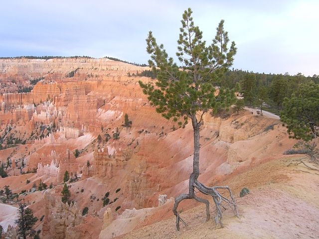
Around 6:10 pm, we arrive at Red Canyon where the colors at sunset seem even more beautiful than we had seen on morning; as the saying goes, every cloud has a silver lining.

_anc12-13_B-10.jpg)
Red Canyon (10 photos)
Thirty minutes later, we enter again into the Bryce Canyon Park and zip in directly to our favorite item, Upper Inspiration Point. And then the magic happens again, it's really wonderful.

Inspiration Point (11 photos)
An hour later, we are at Sunset Point for the sunset but with our polar because it's windy and furthermore chilly (63°F).
The following photos are not necessarily classified by location but rather to try to show the evolution of the sunset, particularly with shadows and brightness.
After the show, we go to the south camp to see if we can find a place (this is a first come first served camping) and, hopefully, we find one.
I light the fire with wood picked up during our last night (near the corral) and we dine in its glow, calm prevailing around us.

.jpg)
Sunset Point (23 photos)
Monday, June 15
While walking, perhaps not very awake and to save time, I erase the card in my camera; and "shit", I just have confirmed that I'm aware of
my stupidity but it's too late . I don't have pictures of Red Canyon and Zion  . Fortunately,
Isabelle doesn't make the same error (I would realize later that I can recover pictures on her formatted cards but not on mine; difference of units without doubt).
. Fortunately,
Isabelle doesn't make the same error (I would realize later that I can recover pictures on her formatted cards but not on mine; difference of units without doubt).
We don't have beautiful colors, a huge cloud being "parked" in front of the pale morning sun.
_B-20_R-10.jpg)
_B-20_R-10.jpg)
_B-20_R-10.jpg)
_B-20_R-10.jpg)
Sunrise Point (9 photos)
We're back at 6:35 at the campground; breakfast, toilet and we save photos (remaining, grrr!) on our external disk.
One hour later, we leave the camp (50°F) and we stop at the VC, skipped during our first visit.
We start at 9am to Hole in the Rock Road for a quick visit to Peek-A-Boo. We drive the road quickly to Escalante and the track at the maximum possible
speed, which allows us to reach the trailhead at 10:53 (with 75°F on thermometer).
Beginning of the descent at 11:02 and, as time is getting short, we run down the hill and 15 minutes later we enter into Dry Fork with a very different light and colors of our first visit, which shows the importance of hour. And we leave this first canyon with a beautiful datura.

Dry Fork (15 photos)
We leave again, still on the run, passing without stopping at the entrance of Peek-A-Boo to reach Spooky Gulch, slot canyon just
as beautiful and as narrow  .
.

.jpg)
Spooky Gulch (18 photos)
After this wonderful visit of Spooky Gulch, we return to the entrance of Peek-A-Boo with its pond, its arch and its daturas.
Some pictures and we go back to the car.
We make the ascent always running, poof, poof ... poof, and 18 minutes later, we arrive at the car; not bad, right?
with an external temperature of 86°F.
_retourne-B-10.jpg)
Peek-A-Boo (11 photos)
Back on the track and direction campground of Lower Calf Creek for picnic; in fact, I forgot to ask the ranger (for Marie Lefèvre from VoyageForum)
if it was possible to pass (in hiking) from Upper Calf Creek to Lower and detour isn't so long.
Unfortunately for her, the answer is no.
At 2:55 pm, we start the climb to the handprints and other petroglyphs near the river and less than an hour later, we head to Cedar Breaks,
the day was really speed, but we wanted to redo some taken views, in case of we'll not recover our lost photos.
[No new pictures here, they have been directly integrated into the initial Escalante's page.]
[We are now at the end of the detour to get some pictures and we take again our initial journey, but we have made a detour of about 250 miles!]
ust before arriving at Cedar Breaks, we pass through aspen forests and large ancient lava flows which blocks litter the roadsides; these lava flows dated to about 1000 years and it's strange to see them still bare, without vegetation.
We arrive at campground near 6:10 pm and there, what a quiet; for cons, there are many dead trees. The campsite is half empty, it just
opened four days ago; we have well planned our visit  .
.
Having selected and booked our location, we start to tour the points of view, it's 52 °F and the sun is obscured by clouds, what a pity!
At North View (3,181 m, 10,435 ft), the view is beautiful; it looks like Bryce and I have the impression that the color range is even more important.
The outside temperature being low enough, there is still snow and Isabelle takes the opportunity to take me as a target.

North View (13 photos)
At the beginning of the hike of Alpine Pond (which we will not do), a geological section shows the different layers that can be seen and compares with Bryce Canyon and Zion.
At Chessmen Ridge Overlook, lack of sunlight is even more acute. The elevation is 3,190 m - 40,467 ft, the highest of our journey.

_ciel corrigé.jpg)
Chessmen Ridge Overlook (9 photos)
We finish with Sunset View (3,156 m - 13,354 ft) and Point Supreme (3,155 m - 10,350 ft) with a brief ray of sunshine and we return to our camp. A good fire allows us to prepare dinner on the grill and we finish the day by selecting photos to upload on Picasaweb at our next internet connection.

_B-10.jpg)
_ciel.jpg)
.jpg)
Sunset View & Point Supreme (14 photos)
