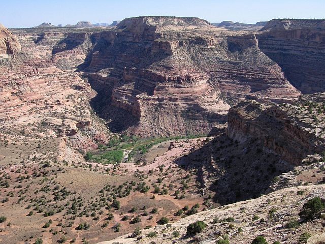
The Wedge (Utah's Little Grand Canyon)
![]() version française
version française
Pictures are small in size and grouped in gallery; just a click on it and you'll have all the gallery in bigger size!
Easy navigation with left or right arrow on the keyboard; leaving the gallery photo by Escape.
Do not forget to switch to full screen (F11). Javascript is required.
Journey map
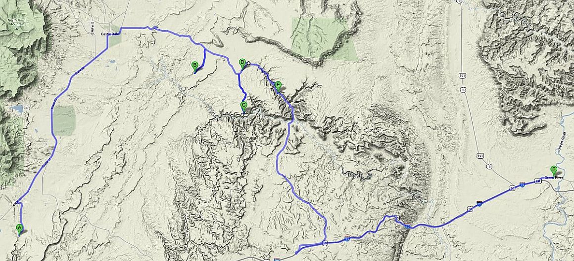
Approximately:
- from Rochester Panel (A) to Hamburger Rocks (B): 41 miles and 1h35 on road/dirt road
- from Hamburger Rocks (B) to Little Grand Canyon (C): 12 miles and 0h40 on dirt road
- from Little Grand Canyon (C) to Buckhorn Draw Pictograph Panel (E): 12 miles and 0h35 on dirt road
- from Buckhorn Draw Pictograph Panel (E) to Green River (F): 54 miles and 1h30 on dirt road/road
J40 - Tuesday, June 19 (continued)
We leave Rochester Panel then take the UT-10 N towards the north. Lunch stop at Ferron, charming village, elegant, green, changing us of
almost dead and desert cities crossed before (I also sent a congratulatory message to the mayor). We found, almost at the northern end of the city,
some sheltered picnic tables equipped with barbecue, toilet; very nice break.
We leave again at 2:10 pm, again with 81 °F. Short stop at State Liquor Agency of Castledale to top up our reserve of appetizer
then we take a road on our right just out of the town: Green River Cutoff Rd (Rd 401). This road, sometimes track but still
very passable even with a RV, first begins by climbing Oil Well Dome
then descends into Hadden Flat then back in the Black Hills. At Little Cedar Mountain, we take a track
on right (Rd 404), along Favorite Hills to go to Hamburger Rocks, small rocky curiosity surely nice with children.
Back on the road and then turn right 2 times for Fullers Bottom Rd we descend to San Rafael River along The Red Ledges
but without finding beautiful photographic opportunities. Moreover, impossible to stay near the river, horseflies are there and attack
quickly  .
.

Hamburger Rocks (11 photos)
We go up the trail at a gallop  , this time taking the first track on right,
Wedge Rd (Rd 405), to drive to its end (The Wedge) and find out where to spend the night; there are several developed sites
from both sides of Good Water Canyon and near the rim overlooking the San Rafael River (no camping elsewhere).
, this time taking the first track on right,
Wedge Rd (Rd 405), to drive to its end (The Wedge) and find out where to spend the night; there are several developed sites
from both sides of Good Water Canyon and near the rim overlooking the San Rafael River (no camping elsewhere).
We begin with a view of the east side of Good Water Canyon (Road 407), but without seeing the river; back to west side.
Our goal is to find a place where to stop the car, switch to night position and then hike to admire the scenery, so not too far from the points of view.
After inspecting all sites along the rim, we choose the "group" camp, the most interesting for us: flat and close to the shore; again there are few people.
Then we go for a walk along Utah's Little Grand Canyon until sunset. This place is aptly named and it's far from the crowd of
its big brother .
We go to bed at 8:52 pm.

The Wedge (23 photos)
J41 - Wednesday, June 20
Wake up at 7:15 (sleep in?), the sky is blue and the air is cooler than usual; the swelling of Isabelle's face seems stabilized and even begins to decrease on her left side.
We leave at 8:35 am with 64 °F. Back on Rd 401 but, formerly discover an open pit quarry of gypsum (slightly spotted yesterday) in Chalk Hills;
the access road is very white and used only by semi-trailers. I don't drive onto it
as I don't want to find myself face to face with one of them.
We then take on right the Buckhorn Draw Rd (Rd 332), this road that goes down Buckhorn Wash towards the San Rafael River. First stop, the
Morrison Knudsen Tunnels where our military friends made experiments (there are several of these tunnels in the area); then we make frequent stops
for the view as the scenery in this canyon is really beautiful and for petroglyphs and pictographs that the canyon is well endowed.

Beginning of Buckhorn Wash (18 photos)
Continuing the walk through the canyon to its most famous panel, the Buckhorn Wash Pictograph Panel. You can't miss it, it's very well marked. These pictographs are Barrier Canyon style,
like those of Horseshoe Canyon.
Many small places to camp punctuate the wash, perfect for RV; in places, speed-limit signs make us smile a little.

Buckhorn Wash Pictograph Panel (29 photos)
We cross the San Rafael Bridge at 11:10 with 66 °F; at its foot, a large camp with many caravans (U.S. size)
). Then the road becomes a track to I-70 but, I repeat,
no problem for any vehicle, RV included. Passage to Bottleneck Peak and other rock formations and we return to I-70 at 0:20 pm.
About 5 miles before, we pass Sink Hole, a hole in the ground probably due to a collapse but with no photographic interest.

_ret_4K_daz30.jpg)
_4K_pxlr.jpg)
_4K_daz30_ret.jpg)
Buckhorn Wash south (29 photos)
Once on I-70, Green River was quickly reached and we head to the Robbers Roost Motel
(where we had booked a few days earlier) at 0:45 pm and 82 °F. The manager being absent until 1pm,
we'll replenish food and take possession of our room at 1:48 pm. The room is small and our cooler larger than the mini fridge,
but apart from that and the floor that tilts a little bit, the tub is welcoming after lunch.
Transfer of our last pictures, in-depth bathing , food preparation for the following days,
Skype, all this leads to mealtime. Direction to La Veracruzana, a few hundred yards away where we eat Mexican (but not margaritas
) and back to our room at 8:29 pm. Upload photos to Picasa for our loyal "followers" and sleep at 10:40 pm.