Mule Canyon Ruins
Newspaper Rock & The Needles
Dead Horse Point & Island in the Sky
![]() version française
version française
Pictures are small in size and grouped in gallery; just a click on it and you'll have all the gallery in bigger size!
Easy navigation with left or right arrow on the keyboard; leaving the gallery photo by Escape.
Do not forget to switch to full screen (F11). Javascript is required.
Journey map

Approximately:
- from Natural Bridges NM SP (A) to Mule Canyon Ruins (B): 15 miles and 30 mn on road
- from Mule Canyon Ruins (B) àto Newspaper Rock (C): 71 miles and 1h40 on road
- from Newspaper Rock (C) to The Needles (D): 20 miles and 30 mn on road
- from The Needles (D) to Dead Horse Point (E): 105 miles and 2h20 on road
- from Dead Horse Point (E) to Island in the Sky (F): 23 miles and 50 mn on road
Friday, May 29
Wake up at 5am, passage of our car in day position and departure quietly to not awake our 3 Americans. At 5:45 am, water heats up for breakfast on the parking lot of the Visitor Center where we're stopped to use toilets (an outdoor electrical outlet lets us even begin to charge our laptop). It's 55°F and the rising sun is glowing rocks. Today, we're going to the ruins of Mule Canyon.
At 7:30 am, the backpacks are already strung and we begin hiking in Mule Canyon for the ruins of House on Fire we reach in less than half an hour. The hike is short and very cool, going up the wash with fresh air (about 68°F).
These are the easiest ruins to reach of our journey and, as shown on ouestusa.fr, photos found everywhere on the net were probably edited, but we were certainly not at the right time. These ruins with evocative nickname (House on Fire, aka Flaming Ceiling Ruin) would be better photographed in the late morning before the sun completely enlightens the canyon.

-ciel.jpg)
Mule Canyon - ruins (12 photos)
The return is done quietly down in the wash, interspersed with numerous stops to photograph the local flora.

Mule Canyon - flowers (26 photos)
Around 9 am, we drive towards Canyonlands The Needles; Canyonlands National Park includes 3 districts:
- The Needles,
- Island in the Sky
- The Maze (were we'll not go (another time?)).
After crossing Comb Ridge, we see the Mount Peale, third highest peak in Utah (12,720 feet) and soon discover Church Rock.
This isolated rock along the road was chosen by a Mormon sect headed by Marie Ogden to make her church in the 1930s. We actually see the entry at the bottom of what looks like a Buddhist "stupa". The sect disappeared before they finished the dig!

-ajust.jpg)
Church Rock (5 photos)
About 20 minutes later, we arrive at Newspaper Rock. This panel of petroglyphs covers a period of about 2,000 years and it shows even post-Columbian motifs, easily identifiable by the presence of horses (the horse would have disappeared in the late Pleistocene).

-ajust-retaille.jpg)
Newspaper Rock (9 photos)
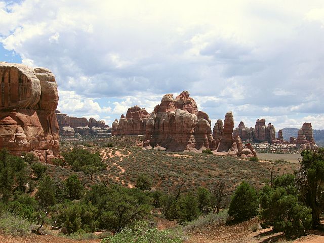
On the road again and all around us, stone mastodons, similar to castles. Their massive structure is completely vertically split from whence may be the name of the park.
Fifteen minutes later, we pass the Sixshooter Peaks (guns are everywhere here  )
and we arrive at the entrance of The Needles district of Canyonlands NP. A small stop at the Visitor Center and we go to the only walk
we'll hike in this park, Chessler Park Overlook. We have our picnic on one of the few tables in the shade at the beginning of the hike,
which is also the beginning of a 4WD track (unfortunately we don't see anyone, as this could have been fun).
)
and we arrive at the entrance of The Needles district of Canyonlands NP. A small stop at the Visitor Center and we go to the only walk
we'll hike in this park, Chessler Park Overlook. We have our picnic on one of the few tables in the shade at the beginning of the hike,
which is also the beginning of a 4WD track (unfortunately we don't see anyone, as this could have been fun).
We begin this hike at 12:45 pm when it's already 81°F. And there, it's an alternation of little climbs, flat ground and downs showing us beautiful landscapes. We go from one valley to another across a very narrow gap (about 2.6 feet).
The climb at the end is not bad either and the thermometer must surely exceed 86°F. This is one of the hikes where we sweated and drunk the most. Oddly, the way back is easier than the forth and eventually we will have done near 7 miles.
Back to car towards 4:15 pm but Isabelle limps, having badly right heel and knees.
This park definitely deserves more of a hike; a next time, maybe in 2012?

_B-18.jpg)
_B-18.jpg)
_B-18.jpg)
_B-18-gamma1_2.jpg)
_B-18_gamma1_2.jpg)
The Neddles - Chessler Park (25 photos)
We take the road to Moab with a brief stop at Wilson Arch and continue to Dead Horse Point SP for sunset. The road is beautiful with its red cliffs and miles pass without problem.
We fulfill our $10 entry fee at Dead Horse Point State Park (the pass is not valid here) and we drive across the entire place to direct us to the point of view and wait for a beautiful sunset.
What a view, it's simply stunning! But the downside is there: clouds, clouds and more clouds which will annul the splendor of the sunset. We take this opportunity to take a look at the landscape:
- Potash basins below,
- Colorado we crossed out of Moab.
The Colorado is there and winds lazily meandering down in front of us before reaching Lake Powell.
A little bit frustrated by these clouds, we leave this State Park accompanied by a few mules deer on the way (care!) and headed to Canyonlands Island in the Sky.

_B-18.jpg)
_B-18.jpg)
-gamma1_3.jpg)
Dead Horse Point (16 photos)
We enter this second part of Canyonlands and quickly arrive at the beginning of the famous Shaffer Trail, trail we try to do tomorrow. From where we are, it seems very impressive indeed.
We leave hoping to find space on the campground of Willow Flat. Nay, this small campsite is already full, but the Philippe's method is always ok. No chat as it's late, dinner and bed (10 pm) and it's still 66°F.

Shaffer Trail (2 photos)
