
Fruita, Nottom & Burr Trail Roads
Hog Spring & Little Egypt
![]() version française
version française
Pictures are small in size and grouped in gallery; just a click on it and you'll have all the gallery in bigger size!
Easy navigation with left or right arrow on the keyboard; leaving the gallery photo by Escape.
Do not forget to switch to full screen (F11). Javascript is required.
Journey map

Approximately:
- from Moab (A) to Fruita (B): 147 miles and 2h40 on road
- from Fruita (B) to Burr Trail Road (C): 43 miles and 2h10 on dirt road
- from Burr Trail Road (C) to Bullfrog (D): 35 miles and 1h25 on dirt road
- from Bullfrog (D) to Little Egypt (E): 46 miles and 1h on road
- from Little Egypt (E) to Fruita (B): 58 miles and 1h10 on road
Monday June 1st
Wake up at 6:30 am and depart for Fruita 3 hours later. At the exit of Moab, the road follows a dark red trench, beautiful, that we l
eave once we arrive on the plateau. A few miles away, the red disappears and we find again the layer of greenish clay (greenish mudstone)
that we had already seen the day before in Mill Canyon.
he landscape along I70 does not leave lasting memories and we take the turnoff to Hanksville at 10:30 am; the sky is overcast and the
outside temperature is 77°F. The road quickly regains its reddish sheen and we spend close to Goblin Valley without stopping. But after
Hanksville, the landscape becomes almost lunar land with dominant yellow-dark gray: we'll only see on July 19, thanks to travel book
of mokahlki (member of VF), that it's Factory Butte area.

Factory Buttes (3 photos)
We arrive at VC around noon. After shopping routine, disappointment: a ranger strongly discourages us that we go in Cathedral Valley,
not so much because of our vehicle, but of big risks of thunderstorms. Exit the night at Cathedral campground in the middle of the valley
 .
.
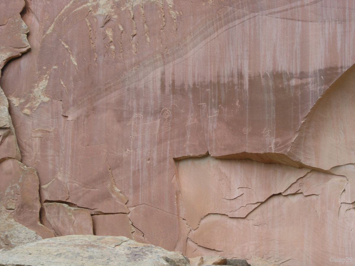
Before lunch and change our plans for the days ahead, we're going to see the petroglyphs along the road, easily observable on a long
wooden runway.

Petroglyphs (10 photos)
Back to the rest area near the VC for lunch (75°F), the location is superb, quiet, and mules deer are nearby. We decide to book 2
nights on the very close campsite where, again, life is good  .
.
Shortly before 3 pm, we drive the Scenic Drive, after slipping our mite. It's 75°F, the sky is very gray, stormy and we feel very big
gusts of wind (the ranger was not mistaken). Indeed, barely 15 minutes later, the rain comes and the temperature drops to 63°F.
After a few photos of old farm machinery, red miracle does again its effect and we're moving in the groove at the rhythm of photo stops.
The guide, found at the following address:
scenic drive,
includes stops sometimes difficult to find. We meet with the geological Shinarump layer, gray-yellowish and rather hard, with debris
littering the ground.
The road quickly becomes dirt and borrows the bed of a dry torrent; we stop after a few hundred meters because of the weather (not want
to get a flashflood!). Back to the main road with a stop at point 3 (you have to take the Grand Wash, occasional refuge of Butch Cassidy),
but we'll not go too far down the runway, always mindful of the weather.

-ciel_B-18.jpg)
 ciel_B-15.jpg)
_gam0-7.jpg)
Scenic Drive (20 photos)
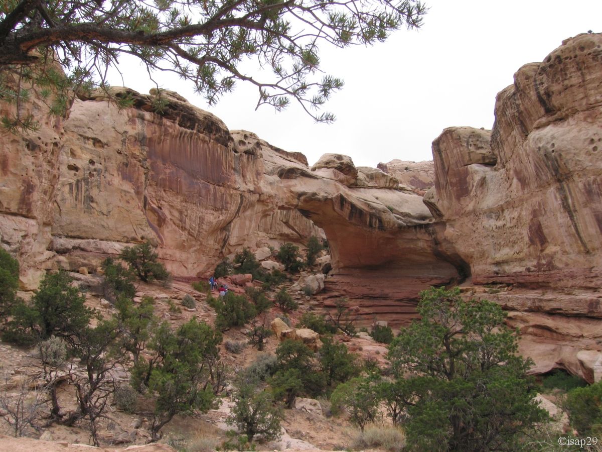
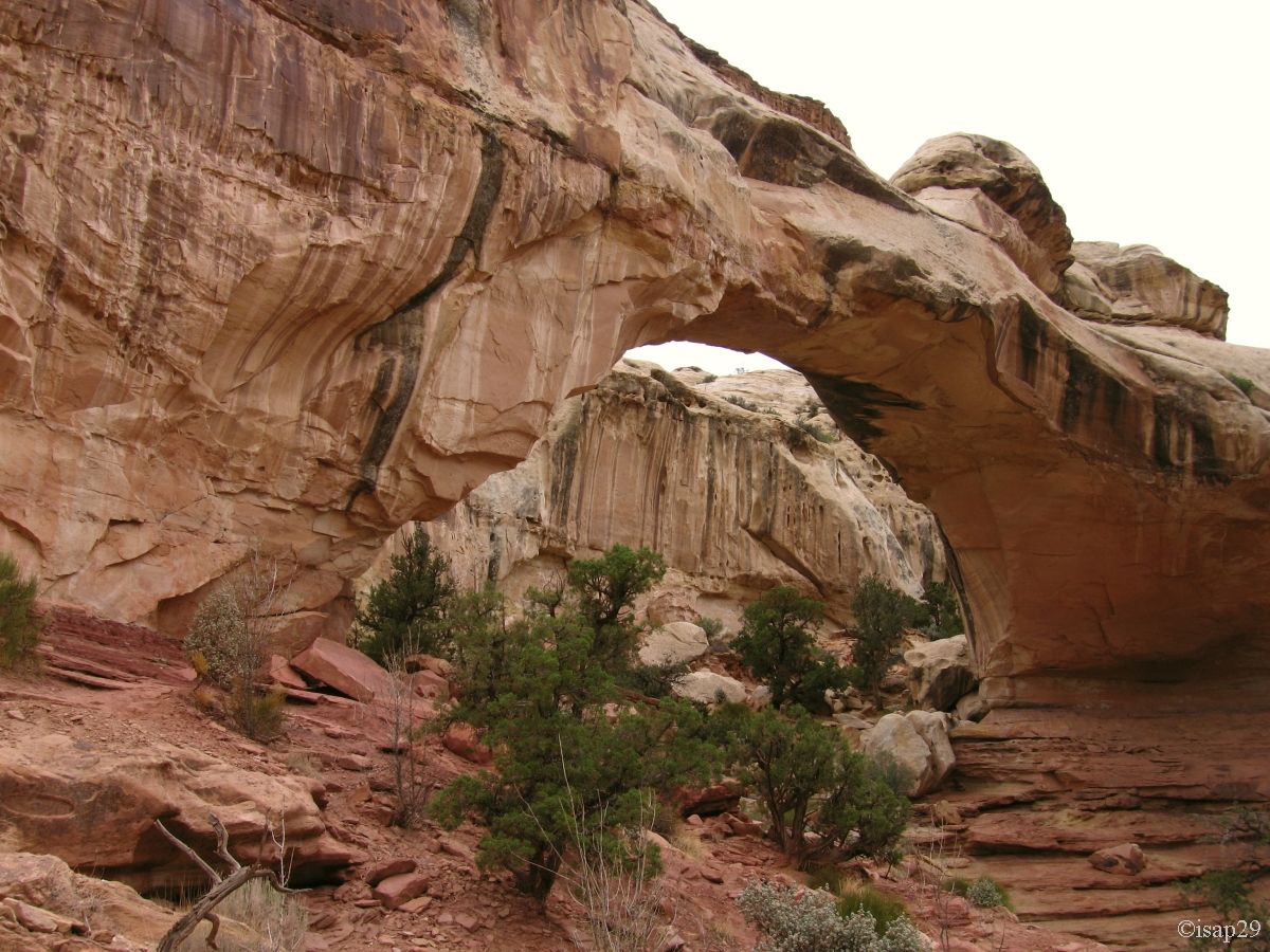
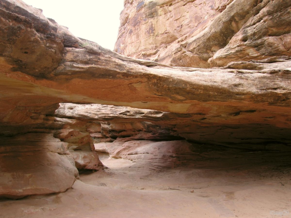
Around 5 pm, we start the hike to Hickman Bridge with the k-ways on our backs but, because of perspiration, they will be promptly
removed (it's soon becomes a sauna below). The track and the sides are littered with black blocks, remnants of ancient lava buffeted
by glaciers.
Along the way, we discover an old Fremont attic then, quickly, the bridge. The sky is now of a quasi uniform light gray and with
strong luminosity; it doesn't rain any more. The way back is in the bed of the stream which had dug fun holes.

.jpg)
Hickman Bridge (26 photos)
Departure for Panorama Point with fortunately a bit more blue in the sky; the storm seems to have receded. Nice view of the cliffs
and mountains in the distance. Then close up on the Goosenecks of Sulphur Creek; it's hard to imagine that this small stream below is
responsible for so much damage  !
!
To finish the day, we head to Sunset Point as the sun is for once at the rendezvous. Back at the campsite at 8:10 pm, dinner and
sorting photos (for the next Internet connection); sleep.

_ajust-cont20-sat40.jpg)
.jpg)
_ajust.jpg)
Panorama Point, Goosenecks & Sunset Point (16 photos)
Tuesday, June 2
After breakfast and shift the car in day position, we have a beautiful sunshine and birds are chirping in the trees, numerous and
very green (trees, eh, not birds ).
We start at 8:10 am for the Nottom Road after our itinerary change. Some works on the road show us that even "small" trucks are pretty.
The track is very fast and easily and we see on the left side, near Sandy Creek, a ranch where watering works at full speed:
it's very green.

Sandy Creek (9 photos)
Shortly before the junction with the Burr Trail road, I nearly crushed our first snake. Fast reverse and Isabelle can capture this
event; it must be a Bull snake or Pituophis sayi catenifer, non-venomous snake. But the guy does not want to pose and we leave for
the intersection.
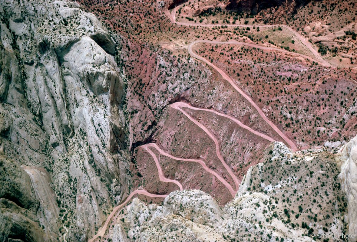
While we seek to see the famous switchbacks, a car that we have already passed, borrows the Burr Trail Road and we wait to see it before
to take some pictures, just to show the famous "Switchbacks". (I take this opportunity to add 2 pictures with the courtesy of the NPS).

Burr Trail Switchbacks (7 photos)
We set out again at 10 am and, in our documents, a hike at Halls Creek Overlook is indicated. We attack the track (and there, it's a
true track) and arrive quickly at a place where another car is stopped; the track continues, but we also stop because it really starts to
jerk and we move so quickly on foot, if not faster. Anyway, we were almost arrived.
Some panels explaining the Waterpocket Fold and Brimhall Bridge, which we see on the other side of the valley. Even if we don't understand
any of the local geology, the sight is very beautiful and the trip worth it.

Halls Creek Overlook (18 photos)
Back on the Nottom Road where we see the distant Henry Mountains. After a brief overview of Lake Powell, we pass near Muddy Canyon which seems well to bear it's name, shortly before arriving at the parking lot of Pedestal Alley; it's noon with 82°F.

On the track (5 photos)
After the usual ritual (sunscreen, walking shoes, backpacks filled, hats and outdoor gps with registered parking), off we went; at the
trailhead, the box with explanatory leaflet is hopelessly empty, which will cause us a problem later. The beginning is in a wash, and
quickly, we lose track of the stakes indicators. We continue up the cliff and find some cairns and small hoodoos. A long traveling shot
on the left where some cairns show us the way and we leave in the sand.
Soon, we lose all trace of indicators and, although traveled in every direction, we find no tracks (Philippe will confirm later that
we were at the end of the trail).
Back to the car at 1:45 pm with 89°F; whole (small) hike is without shadow, but it's nice and almost no gradient.

_B-15.jpg)
Pedestal Alley (13 photos)
We arrive at the intersection of Highway to Bullfrog (Hwy 276) and I prefer to make a jump to refuel: $2.719 the gallon (expensive) and totally unnecessary, because on the other side of the junction there are major repair of storage-boats (the lake requires) and fuel is cheaper.
At 3:50 pm, we end up eating on the parking lot from where begins the path to Hog Springs. This pleasant hike, although in grasses
and brush that annoy Isabelle, must lead us to a small perennial waterfall and a nice plunge pool. The beginning worries me a little
because if the fall is perennial, we should see at least a trickle of water running in the wash, but nothing.
And yet the fall does exist, the flow is very low and the tricklet gets lost in the sand.

Hog Springs (8 photos)
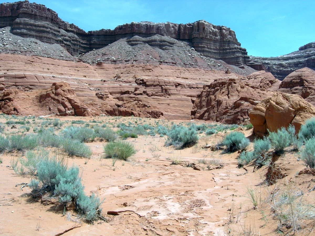
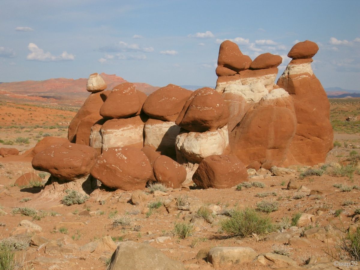
Back to the parking lot and we can't find the slightest trace of petroglyphs in the area; we must be blind. As the day advances, we head to Little Egypt. We hesitated a bit at the junction as it's indicated only Bull Creek Pass, but ultimately it's the right direction. Nice stroll among these tortured rocks, mix of white and red, sometimes arranged like a huge army standing to attention.

Little Egypt (17 photos)
We leave here at 6:40 pm for a dinner in Torrey at Capitol Reef Inn where one third of clients speak French.
