JavaScript is not enabled.
Needed to see the photo galleries.
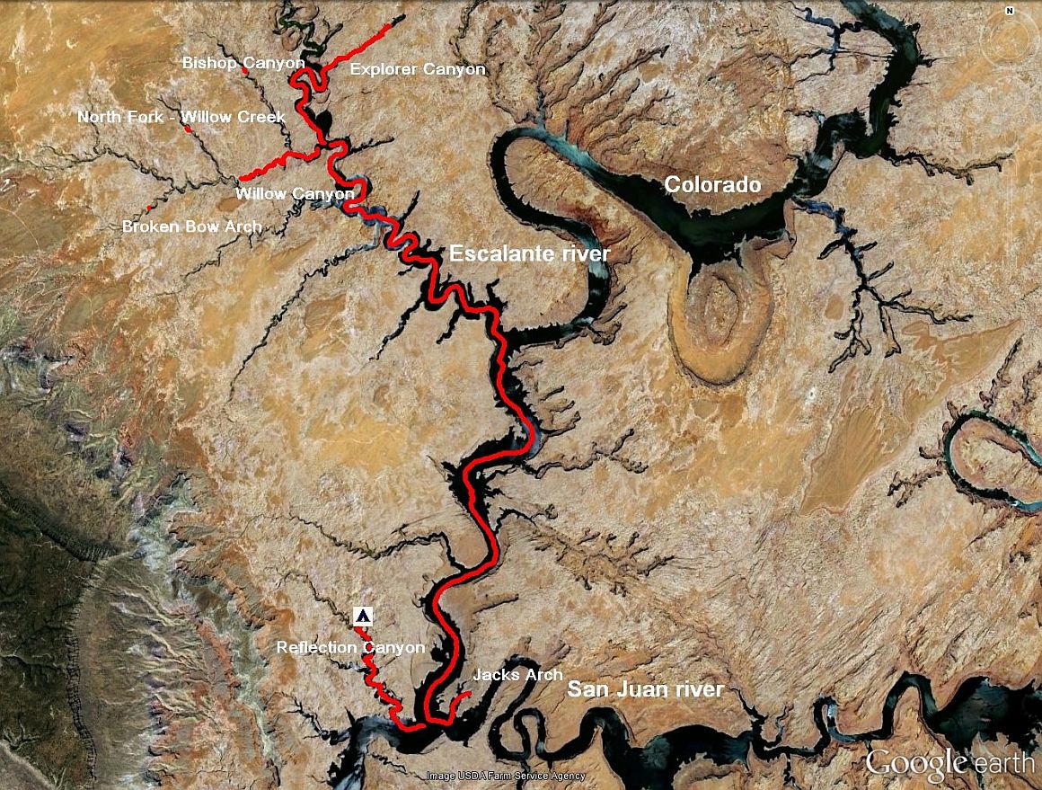
Journey map

J21-Thursday, May 31
Wake up at 6:15 am and we leave an hour later to Explorer Canyon (only one arm of Escalante River to cross). We go as far as
possible and then moor first on the left side, but ultimately we prefer the right one.
Departure at 8:10, a little climb and way finding, the beginning of hike being badly drawn but it improves quickly. We follow the
canyon filled with tree trunks and branches. After one or two half-turns due to track lost, we arrive at the first panel of petroglyphs
at 8:45 then 9:18 at Zane Gray Arch.
At 9:32 am, after finding some other petroglyphs, we are almost at the bottom of the canyon and we make a U-turn (misreading of our
documentation, there was a panel of petroglyphs to see)
![]() ).
).
Some pictures, a little water and we continue. We're back to our boat at 10:40 am with 3.2 miles on pedometer. We take our shoes off on
the rear of the boat, our shoes being full of sand, and we enjoy a well-cooled drink, took out of the cooler
![]() .
.
The hike was almost full sun, facing east.
Explorer Canyon (24 photos)
Departure at 11:35 am for Willow Canyon, hoping to reach Broken Bow Arch that we had not seen in 2009 due to heavy risk
of thunderstorm.
We quickly pass Bishop Canyon and ascend Willow Creek as far as possible, but when the propeller raises clouds of mud, we
don't see how to continue, even putting our dinghy to water: too many branches and no visible trail on the banks. We're almost at the
mouth of North Fork - Willow Creek. Too bad, we will not see Broken Bow Arch.
We make a U-turn to 12:45 pm and stop for lunch in the shade of a large section of the cliff. We are dying of thirst but, as the thermometer
is part of the car, we have no clear idea of the temperature, but it's hot, very hot.
After lunch, we descend now Escalante River and Colorado River. At the mouth of the San Juan River, foray into the small cove just at the head
of the river to search Jacks Arch. Small missed training, we would have accost and walk; damage.
![]() .
.
Never mind, we still find an arch, so young that we only see the sunlight through.
Willow Canyon (14 photos)
We cross the Colorado to reach Reflection Canyon where we will spend the night with the advice of
Michael Kelsey. After meeting a mother duck and her ducklings, we come to the end of navigable canyon.
I go alone to explore the top of the canyon; there must petroglyphs on the left bank. But after trying to cross
several times (I'm sinking a lot in the soft sand), hiking extensively in soft sand, I make a U-turn and return
to boat, even having lost the cache of my lens when crossing of a "big bush". In the nearby lagoon, inaccessible
on foot or by swimming as the bushes are dense, large snaps on water: beavers? We'll never have the answer.
A good bath to refresh, some photos of "reflections" and cocktail, dinner and sleep in peace, our neighbors "beavers" being asleep.
Reflection Canyon (16 photos)


