JavaScript is not enabled.
Needed to see the photo galleries.
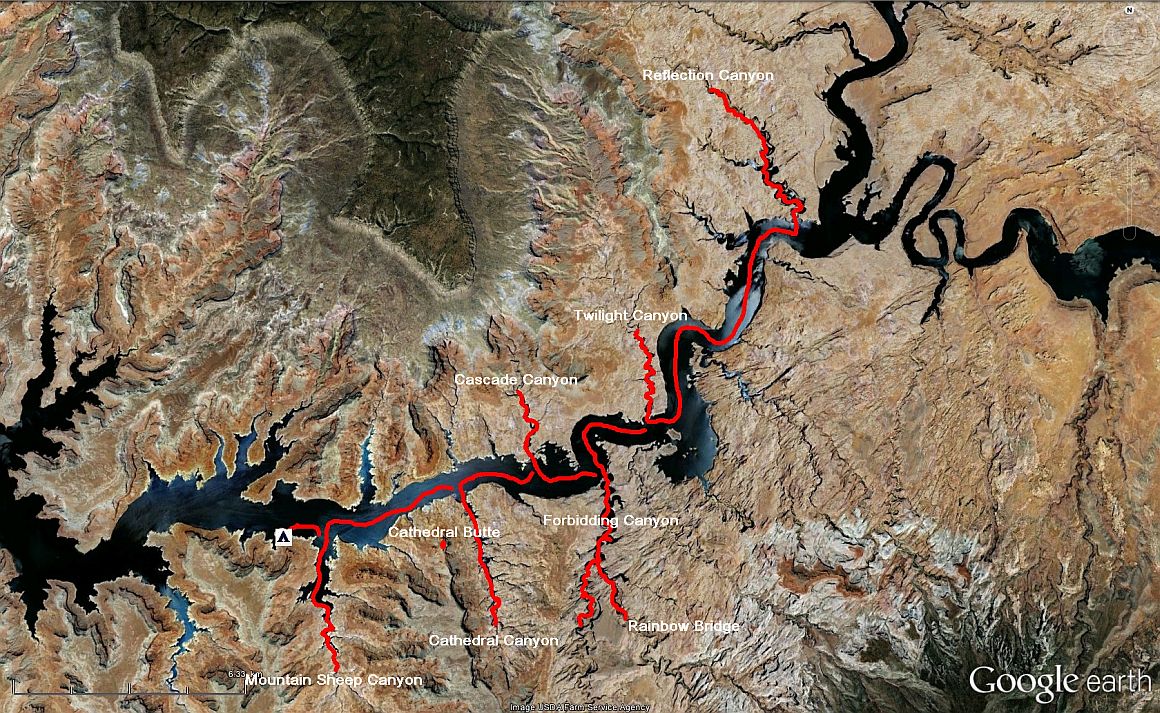
Journey map

J22 - Friday, June 1
Wake up at 5:30 am, our "beavers" of the night before continues their sound effects but still impossible to see them,
even with the boat, as the "Kelsey's beach" is very crowded with trees and shrubs.
On water, we find again mother duck and her family practically under ruins perched in an alcove.
At 7:39 am, we stop at the internal junction to try to climb and have a semblance of the photo of "Michael Melford"
![]() . First try, I miss; the climb is a little bit difficult and I didn't want to break my neck.
Second test, I pushed a little and Isabelle managed to pass the first hurdle and continues to climb. Waste of time, the next
cliffs mask the view, one should go much higher.
. First try, I miss; the climb is a little bit difficult and I didn't want to break my neck.
Second test, I pushed a little and Isabelle managed to pass the first hurdle and continues to climb. Waste of time, the next
cliffs mask the view, one should go much higher.
Isabelle prefers I fetch her with the boat on the other side of the point, the descent seeming easier for her via a scree.
She finishes anyway, fortunately without harm, in water up to her waist, trying to get on board
![]()
![]()
![]()
![]() . And it ends with a bath for both of us.
. And it ends with a bath for both of us.
Time to dry us, change us, it's already 8:45; too late to try somewhere else because our schedule is pretty tight. So we leave quietly to the
exit of the canyon we reach 15 minutes later, we must take a few photos.
Reflection Canyon, at dawn (16 photos)
We continue the descent of the Colorado River and, 20 minutes after, we enter Twilight Canyon. The entry is not specified but is just north of the buoy 51. We sail up the canyon to the fork, passing near Twilight Arch and the ride is very nice. Be careful though, in a bend, a rock almost flush with the surface.
Twilight Canyon (14 photos)
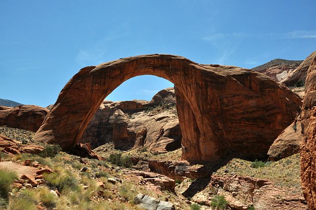
Back in the main channel at 10:20 am and we cross Colorado to enter, a little lower, in Forbidding Canyon then left in Rainbow Bridge Canyon
and the equally famous Rainbow Bridge. This bridge is the largest in the world, the sixth if taking arches into account.
The end of the trip is almost as idle, as speed is very limited; there is actually a lot of traffic and waves could be reflected on
the walls, creating very choppy water and sometimes wave crests.
Michael R. Kelsey says (Boater's Guide to Lake Powell) he have nearly capsized, the speed was not limited at this time.
At 10:50 am, we are moored at the dock; an American with whom we talk shows us his boat, far better than ours: a Chaparral Signature 260; beautiful machine!
Back to boat at 11:45 am after talking with a ranger who escorts us almost under the bridge (it is forbidden to go below, out of respect for the Navajo beliefs).
Rainbow Bridge (16 photos)
We return into Forbidding Canyon and find a shaded area (they are not legion at this hour) ![]() .
.
Successful anchoring on the second attempt and immediately we take a bath to cool down ![]() .
.
While Isabelle prepares for the meal, I closely check the propeller and see some small marks and deformations (would we have hit the rock?). In doubt,
I grab a piece of sandstone and refine the edges. After 30 minutes of "sanding" the propeller seems to me very well.
We leave at 2:20 pm to the canyon but we must stop for lack of water and, finding the sand too soft for a pleasant walk, we turn back.
Forbidding Canyon (19 photos)
At 3:04 pm, we enter into Cascade Canyon, the narrower canyon we've had so far, very nice, although sometimes we wonder if it will pass!
U-turn 25 minutes later and we go on Cathedral Canyon, long canyon where narrow parts are interspersed with more larger areas; in places,
no more than 20" on each side of the boat.
Cathedral Canyon (13 photos)
We turn back at 4:18 pm and continue in Mountain Sheep Canyon with cliffs lesser high, but also very narrow and twisty at the end.
So we prefer to turn around before we get stuck.
At 5:20 pm, we anchored for the night a little further than the mouth of Mountain Sheep Canyon (near buoy 44), the beaches are quite rare.
In this way, we will not have a lot of sailing to do tomorrow morning, Dangling Rope is
almost in front of us and we must refuel.
Bath, writing of postcards, sunset under the moon, dinner and then sleep.
I use a new kind of bedding, directly on the back seat of the boat, it makes it that much cooler in the cabin. A large cloud of gnats is
"parked" just behind the awning; it's sound like an awesome noise but they don't come to disturb us too, phew!
Mountain Sheep Canyon (20 photos)


