JavaScript is not enabled.
Needed to see the photo galleries.
Pictures are small in size and grouped in gallery; just a click on it and you'll have all the gallery in bigger size!
Easy navigation with left or right arrow on the keyboard; leaving the gallery photo by Escape.
Do not forget to switch to full screen (F11). Javascript is required.
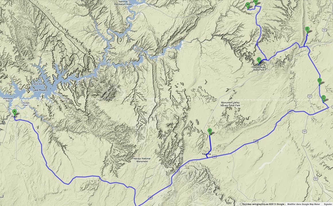
Journey map

Approximately:
- from Page (A) to Agathla Peak (B): 107 miles and 1h45 drive on paved road
- from Agathla Peak (B) to Boundary Buttes (C): 60 miles and 1h05 drive on paved road
- from Boundary Buttes (C) to Butler Wash (E): 27 miles and 1h drive on paved road/dirt road
- from Butler Wash (E) to Goosenecks SP (F): 25 miles and 0h45 drive on paved road
- from Goosenecks SP (F) to Sheiks Canyon (H): 33 miles and 1h10 drive on paved road/dirt road
J25 - Monday, June 4
Wake up at 6:15 am, breakfast, luggage reorganization, preparation of the car and we leave the motel at 10:20 towards Safeway and
Wallmart. We finally find a pair of shoes for Isabelle (ugly, flashy, horribly expensive - $ 150 and not even real hiking shoes)
and we set off at 11:15 and 91°F.
It's with a bit of nostalgia that we leave Lake Powell for a transition towards the south Utah.
Initially, I planned to take the Hwy 89 and, at The Gap, to cross the Navajo reservation to join the 98 in Kaibito.
Given the time spent finding shoes, that's for another day and we go directly to the Hwy 98. We refuel in
Black Mesa, just before Kayenta.
We take the Hwy 464 towards Monument Valley to see Agathla Peak with a few stops along the way for some photos. At
1:20 pm and 93°F, we still don't have lunch and we can't find shade. Little discussion with French people who are reluctant to go
on Navajo land but we go and do the tour of El Capitan (Agathla Peak). This peak, remains of volcano, is considered sacred by the Navajo.
Agathla Peak - we go around (19 photos)
We leave and stop at the foot of Church Rock in full sun and have lunch in the car with air conditioning. It's 93°F.
We leave again at 3:17 pm, always on the 160 towards Boundary Buttes and here we get lost on dirt road and go back on the 191,
ending up finding our way. Then, we drive towards Utah and 163 (near Bluff). At 5:25 p.m., we arrive at the entrance of the
Butler Road track; the gate is closed, but two 4x4 are just ahead us and open it, leaving it to us to close it.
Quickly, we arrive at the trailhead parking for Wolfman Panel where we spend the night.
A strong sandstorm completely blocks the horizon. Sleep at 8pm.
Along Hwy 160 and 191 (11 photos)
J26 - Tuesday, June 5
Wake up at 5:45 am on the plateau overlooking Butler Wash; bright sunshine, a little fresh air, pleasant, and no cloud. An American
arrives on site in a 4WD and we chat a bit.
Comb Ridge is a monocline (the kind of Waterpocket Fold), stretching from north to south and about 90miles with a steep west side
(Combe Wash) and softer east side (Butler Wash); for those who love geology, there are Chinle, Kayenta and Navajo formations.
This fold is very visible on Google Earth.
There are an impressive number of ruins and petroglyphs on the east side.
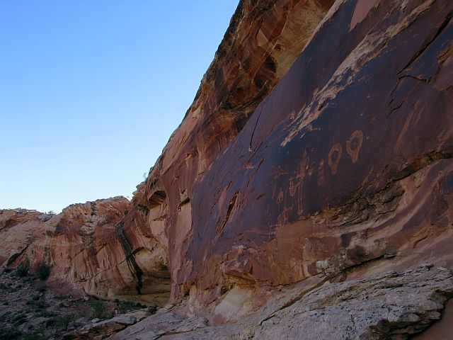
Departure at 7:23 for Wolfman Panel. petroglyphs. The hike is easy; just go due west to the rim, then south following cairns.
We're back at 7:56, it's 82°F. The petroglyphs are superb and totally different from what we've seen. There are even ruins on the opposite
side of the wash, ruins where our American visitor is gone.
Wolfman Panel (12 photos)
At 8:32, we're at trailhead for Monarch Cave. We follow the path and cairns on the slickrock. A little bit of way-finding at
the end and finally we see the ruins; see is the word because they're far, below the hill in front of us and the view from the top is
actually not that great. When going down, we find the path (not seen on the one-way) that should have lead us to the ruins.
Laurent Martrès will tell us later that it isn't "terrible". Back to the car at 9:55 with 2.2 miles on pedometer.
We leave that location at 10:08 for Procession Panel, other petroglyphs site. We come out of the car at 10:33 and cross
the wash without water but with many poplars and shrubs (tamarisk, sage ...).
After a bit of a climb, we arrive on site at 11:20. We are squarely on the top of Comb Ridge with a beautiful view on the other side.
We catch our breath while admiring these petroglyphs and landscape. Light snack and we make our way back at 11:44. We arrive at the car at 12:30 pm,
86°F and 3 miles on pedometer. 25 minutes later, stop snack in the shade (rare) of a branch of poplar; it's always 86°F.
Procession Panel (19 photos)
We leave Butler Wash at 1:50 pm; the wind has picked up and it's now 93°F. We drive towards Mexican Hat but, before, we visit an abandoned meander of the San Juan River. I had noticed it on the topo maps. This meander, we reach it after 4.55 miles on an average condition track. Not spectacular but still interesting to see. From my map, the track joins the road but we finally turn back, its condition getting worse and less and less visible.
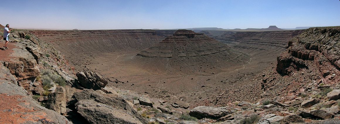
Refueling at Mexican Hat and quick stop at Goosenecks SP that we discovered in 2009. We planned Valley of the Gods but, as we have a meeting at 5pm, we forget all about it.
Goosenecks (4 photos)
This meeting, we owe it to Sedonax which, in view of one of my questions about hiking the next day, advised me to contact
Laurent Martrès, well-known author of Photographing The Southwest (PTS).
In fact, he plans a new reissue of PTS with obviously some changes and additions, including Sheiks Canyon – Bullet Canyon
hike and we agreed to do it together. This hike is interesting for several reasons: first the descent of Sheiks Canyon and ascent
of Bullet Canyon with lovely views and several sets of Indian ruins, petroglyphs and pictographs with famous names (Green Mask, Jail House...).
There would also be an opportunity to go out of the canyon near Jail House (shorter).
As a precaution, I warned Laurent that we are not experienced hikers ![]() .
.
We arrive at the Kane Gulch Ranger Station at 4:30. Laurent is already there, in discussion with a ranger. Presentations (he is with a friend of him
, Charles), discussion with the ranger that discourages us from trying the envisaged exit near Jail House
(unless we're good climbers). We expect a third friend of Laurent, Hiro. But Hiro does not arrive and, after trying to phone him, Laurent decides to reach Sheiks
Canyon trailhead; surprise, Hiro was waiting for us but there is no phone network.
After discussion, we (Isabelle, Hiro and me) stay on the spot while Laurent and Charles go to Bullet Canyon trailhead to leave a car (shuttle) to return on the next day.
Meeting at 6am tomorrow morning, Laurent is a strong supporter of early departures.
Backup of our photos of the day, time change (Utah) of all our devices, diner and sleep.
J27 - Wednesday, June 6
Wake up at 5am; breakfast, transformation of the car and preparation of our backpacks (about 1 gallon each), payment of permits for hiking and I even forget my
paper map ![]() , map found on
Todd's web site, site with many descriptions of hikes.
, map found on
Todd's web site, site with many descriptions of hikes.
Charles and Laurent arrive and, quickly, we start walking at 6:18. We're 5 for this hike: Laurent, Charles, Hiro, Isabelle and I.
From the beginning, Charles - 69 years old and still very vigorous ![]() - takes the lead and sets the pace
that we have struggling to keep up, it promises!
- takes the lead and sets the pace
that we have struggling to keep up, it promises!
At the same time, we are moving quickly as we come to the first important point of the day, Yellow House Ruins, Anasazi ruins.
It's not yet very broad daylight and we must adjust ISO value on our cameras for pictures. The building structure is still well preserved.
We leave again, and after some time, the hike becomes less evident as we move forward in Sheiks Canyon.
At times, despite indications the ranger gave us yesterday, it becomes very difficult and we must explore the two sides of the canyon to find our way, sometimes
with big steps down. Around 7am, a small attic (granary) catches our attention.
Just before 8 am, a landmark, highlighted yesterday by the ranger, reassures us; we are on the right track. Then, a portion a little hard to pass (a ranger has
recently broken her ankle here) and at 8:53, behind a small rocky outcrop, we see Grand Gulch with The Thumb in landmark; we approach the junction.
Yellow House Ruins (21 photos)
Just before the junction with Grand Gulch, second important point of the day, Green Mask. Many panels of pictographs and some ruins.
Long photo shoot, so much the site is interesting for several reasons. While we every 5 snap away each more than the next, a couple of hikers passes
not far, only people we'll see during the day.
We set off again around 9:30; the bottom of Grand Gulch is sandy and full of trees and shrubs. Along the way, we see some ruins, perched on the side of the canyon (sun side).
Green Mask (23 photos)
At 10:40, we reach the junction with Bullet Canyon and take a short break (10 minutes). There, all that remains is just hiking up
the canyon, but the sun begins to be seriously interested with us ![]() .
.
Around 11:45, we arrive at the foot of Jail House, third and penultimate important point, and after dropping our bags, we're off to see
the ruins and other symbols up close.
The name of this site comes from either white round "barred" or the window "bars", maybe the two.
Isabelle, a little tired, waits us in the shade while we yomp on the rocks, looking for a way to reach these ruins. Laurent, as nimble as a goat
![]() , is already in place as we barely begin to climb.
, is already in place as we barely begin to climb.
Again, a long photo session as "subjects" are varied; numerous fragments of pottery scattered on the ground and Charles makes me even noticing
a flat stone, hiding (voluntarily) fine examples.
We join Isabel and do lunch. Already 7.7 miles on pedometer. Laurent suggests I go to see my "famous" possible exit, but heat and fatigue as well
as the remark of the ranger, make me slip back.
Jail House (20 photos)
At 1pm, we continue our hike; next stop at Perfect Kiva A little tired, I make a stop and let them alone, Isabelle will tell me ![]() .
This kiva, probably used for religious ceremonies, has been restored to the same and is in perfect condition.
.
This kiva, probably used for religious ceremonies, has been restored to the same and is in perfect condition.
Perfect Kiva (10 photos)
And here we go for the beginning of the last part of the hike near 2pm. Long climb in Bullet Canyon, in hot sun,
to the parking lot where Charles left his car. After a while, it begins to show signs of fatigue and Laurent offers
to exchange their backpacks. We continue but, shortly after, another stop, light snack and we leave. Our water level
drops visibly; only Charles, perhaps more foresight, has still a little more.
New beginning but soon new stop: hypoglycemia or hyposodia? We offer Charles dried fruits, full of fructose; it seems
to be good for him and we leave again but the improvement is short-lived. New stop, a little bit more long.
There are, in the canyon, several rather delicate places to cross and we follow the path (there may be others) which winds
its way above the bottom so as to avoid these difficulties.
We finally arrive at the end of our journey into the canyon; there is no more water in my backpack, no more water
in Isabelle's one nor in Hiro's one. Fortunately Charles can help us out again. But soon, a doubt arises: where is
the exit of the canyon? The car is waiting for us on the flat, not in the bottom!
First test of climb to find a way out but it does not work, it failed again and again, no way out of the canyon.
After a time, using the map of Laurent and GPS, it seems clear that we have gone too far away of the parking lot.
But, what to do? Going down seeking an escape or continue to go up the canyon? We go up then, during a break, Laurent continues alone and, a little later, calls us: he finds a way out.
Relief of all, we finally arrive on the flat but completely dry, no one has water, Laurent' lips even limit "parchment".
We arrive at the car park at 7:20 pm and Charles, always him, gives us fresh water of his car: a true treat
![]()
![]()
![]()
![]() . On our pedometer, we have 13.8 miles instead of 10.5 miles theoretical.
It's clear that we went back too far.
. On our pedometer, we have 13.8 miles instead of 10.5 miles theoretical.
It's clear that we went back too far.
I stay with the backpacks while others go with the car of Charles, recover other vehicles remained at
the trailhead. They are back a few moments later.
Lawrence had an appointment in the Needles SP with Philippe Schuler (Sedonax on VF) but the day is too late.
He will leave anyway later and Charles too, to Blanding. However, I don't let him leave us like that
![]() and, after the thanks that are required, I now have a copy, used certainly, of PTS autographed
and, after the thanks that are required, I now have a copy, used certainly, of PTS autographed
![]()
![]()
![]()
![]() .
.
We have appreciated the true value of the day, even if the end was a little "tricky" and I truly believe that,
without Laurent and his friends, we would have turned back by the end of Sheiks Canyon.
We stay alone with Hiro, and after a well deserved cocktail, dinner and bedtime at 10pm.


