JavaScript is not enabled.
Needed to see the photo galleries.
Canyonlands Overlooks
![]() version française
version française
Pictures are small in size and grouped in gallery; just a click on it and you'll have all the gallery in bigger size!
Easy navigation with left or right arrow on the keyboard; leaving the gallery photo by Escape.
Do not forget to switch to full screen (F11). Javascript is required.
Journey map
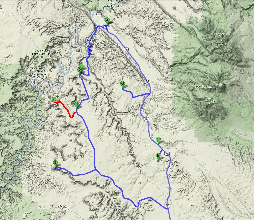
Approximately:
- from Butler Wash (A) to Needles overlook (B): 108 miles and 2h30 drive on road
- from Needles overlook (B) to Canyonlands Overlook (C+): 38 miles and ~1h drive on paved road/dirt road
- from Canyonlands Overlook (C+) to Anticline overlook (D): 27 miles and 0h40 drive on road
- from Anticline overlook (D) to Looking Glass Rock (E): 43 miles and 1h40 drive on road
- from Looking Glass Rock (E) to Balcony Arch (G): 18 miles and 0h40 drive on paved road/dirt road
- from Balcony Arch (G) to Moab (J): 18 miles and 0h30 drive on paved road/dirt road
- from Moab (J) to Hurrah Pass (I): 14 miles and 0h40 drive on paved road/dirt road
J28 - Thursday, June 7
Sunrise 6:45 (Utah time). Very blue sky, no wind.
Yesterday, when Laurent talked to me about Philippe, I immediately jumped at the chance and, as Laurent didn't find my daytime program very special,
we decided, even if the meeting with Philippe is missed, to forget all about this part. This will allow us to have one day of rest in Moab
 .
.
We leave our site at 8:35 am, 68°F on thermometer, towards Hatch Point and all its views on Canyonlands and Colorado.
We go on Hwy 261 to the Natural Bridges NM then turn right on the 95 towards Monticello and Blanding with a beautiful crossing of Comb Ridge and finally on the 191.
We turn left on Hwy 133 (Needles Overlook Rd) and, after a brief stop at Jail Rock, we arrive at Needles Overlook at 11am.
Stroll during 50 minutes staring hungrily at landscape with stunning visual panoramas (what will happen to our photos?).

Needles Overlook (11 photos)
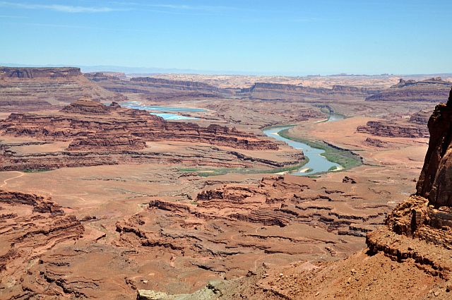
Departure for Canyonland Overlook and we arrive at the first point of view at 0:38 pm. But to go there, 4WD is mandatory because this
long track is very sandy in places, although rocky in other places. However, we find this first point of view fairly average.
We're back, still on the track and quickly enough, we reach the second point of view and there, that's fine, we enjoy
. Stunning views of the settling ponds of potassium salts and Colorado.

Canyonland Overlook (7 photos)
The dirt road continues, ever westward but becomes increasingly 4x4 then we make a u-turn at 1pm and drive back on the main track at 1:28 pm and arrive at Anticline Overlook
near 1:40 with 75°F.
Once again, the landscape is huge with stunning views of Kane Springs Rd and Hurrah Pass for example. After the photo shoot, we have lunch under a tree,
accompanied by flies and gnats.
We leave again at 3pm and after a very quick passage at Minor Overlook and Wine Glass Arch, we arrive on Hwy191.

Anticline Overlook (12 photos)
On the 191, shortly after Wilson Arch, we take on the left Rd131 (Looking Glass Rd). We arrive at Looking Glass Arch at 4:06 pm and 82°F.
After a few photos, we try to go around to see the ark of the other side but the track that we take is very "sandy" and ends on a fence; u- turn.
Back on the 191, then left on Behind The Rocks Rd to Prostitute Butte (don't ask me the origin of the name  ).
Many camps on the left of the track, sandy in places, rocky in others (4WD or SUV compulsory). We arrived at 5:13 and immediately discover Balcony Arch; then we
continue on foot as Picture Frame Arch is on the other side of the hill (west side) and I dare not go by car, since the soft sand on runway is very thick.
).
Many camps on the left of the track, sandy in places, rocky in others (4WD or SUV compulsory). We arrived at 5:13 and immediately discover Balcony Arch; then we
continue on foot as Picture Frame Arch is on the other side of the hill (west side) and I dare not go by car, since the soft sand on runway is very thick.
We return on the back side of the hill and I propose to Isabelle to sleep on site (there are a lot of traces of fire), but she prefers to continue because
there are many unidentified flying insects .
We left at 5:47 pm and there, thinking to take a shortcut, I get it wrong and we end up on an unknown track, very sandy and, as our friend Tomtom says, takes us away from our path.
U-turn at the first opportunity, accurate recovery of our way and, phew, we find our way.
Stop at 6:22 pm (86°F) in one of the many campsites seen. This is fun! we are alone ;
so we can choose our site quietly.
Finally, we believe to be alone as scarcely out of the car, it is the invasion: flies, midges, gnats and other "pranks" dance a frantic saraband around us, on us
 .
.

Balcony Arch & Picture Frame Arch (18 photos)
Disappointed, we can't stay in these conditions. What to do? The day is well advanced but we head for Moab, tough. We stop at the Super 8 at 7pm (91°F): it's full. The same at Bowen
Motel but we reserve the nights of 11 and 12 (we were already at this motel in 2009).
We continue our tour of hotels and this is the same everywhere: tomorrow there is a great famous hike and three films shooting, it's not surprising. Finally there is a room at Rumada,
but $ 220 (plus taxes ), it's not for us. Same as Bighorn Lodge, but as we crossed the road, Chara (from front desk) runs after us and
announces the news: there is a withdrawal at the Rustic Inn and a room available for $ 100. Thank you Chara.
We don't choosy and jump at the chance. In the end, we will have a suite for $ 112.29 incl.
We are settled at 8:20, drink, transferring photos, emails and Skype calls in France, dinner and sleep at 11:10 pm.
J29 - Friday, June 8
Sunrise at 6:15 am and depart at 8am. We take Kane Creek Blvd along the Colorado and Kane Springs Rd 3D snaking along the creek of the same name
. Very nice road with splendid views in the morning sun. The road quickly becomes track, but no problem
with a passenger car. Short stop at Birthing Rock Petroglyphs then we cross a wash, just before the start of the track to Hurrah Pass.
From this wash, a SUV is compulsory!
We continue on the track and find again the landscape seen from above yesterday; we are at the foot of Anticline Overlook and you can see the protective barriers views yesterday.
At 9:15 am with 77°F, we start the "climb" to Hurrah Pass.
Very quickly, the track becomes very "rough" to the point that we prefer to make a u-turn to spare our tires. Too bad, I think the view of the pass would have been nice, but
it's still a rental car and our first experience with a 4WD.
We have done worse, finally, a few days after .

-ciel_4K_daz50.jpg)
_B-20_daz50.jpg)
_4K_daz50.jpg)
_B-20_daz30.jpg)
_4K_daz30_V10.jpg)
-sol.jpg)
-ciel_4K_daz50.jpg)
Hurrah Pass (18 photos)
Around 9:50, we're back to civilization (Moab), along the Colorado with its multitude of electric cables.