JavaScript is not enabled.
Needed to see the photo galleries.
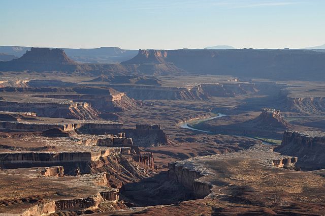
Canyonlands - Island in the Sky
![]() version française
version française
Pictures are small in size and grouped in gallery; just a click on it and you'll have all the gallery in bigger size!
Easy navigation with left or right arrow on the keyboard; leaving the gallery photo by Escape.
Do not forget to switch to full screen (F11). Javascript is required.
Journey map
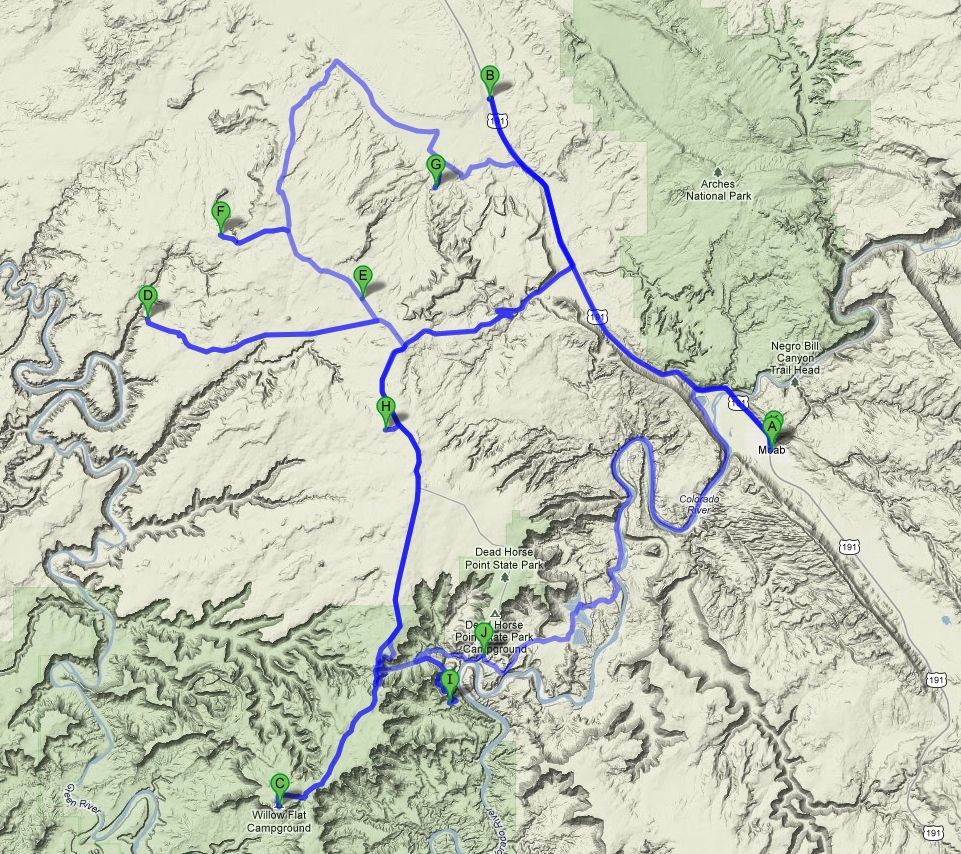
Approximately:
- from Moab (A) to Canyonlands Field (B): 18 miles and 0h20 drive on road
- from Canyonlands Field NP (B) to Willow Flat (C): 36 miles and 1h drive on road
- from Willow Flat (C) to Spring Canyon (D): 32 miles and 1h30 drive on dirt road
- from Spring Canyon (D) to Lost World Butte (F): 17 miles and 1h05 drive on dirt road
- from Lost World Butte (F) to Tusher Tunnel (G): 18 miles and 1h15 drive on dirt road
- from Tusher Tunnel (G) to Horsethief Campground (H): 22 miles and 0h40 drive on paved road/dirt road
- from Horsethief Campground (H) to Musselman Arch (I): 18 miles and 1h drive on paved road/dirt road
- from Musselman Arch (I) to Moab (A): 36 miles and 2h drive on paved road/dirt road
J29 - Friday, June 8 (continued)
Refueling at City Market we already know and which provides, among other, salads you make up yourself.
Departure at 10:30 am with 82°F to the airport and we reserve for June 13; appointment at 10am with, in program, a 2 hours flight.
We'll talk soon  .
.
We lift the airport at 11:12 and take the direction of Island in the Sky with, along the way, a few photo stops on Monitor & Merrimac Buttes, so named after a resemblance to two ships the Civil War.

Monitor & Merrimac Buttes (7 photos)
We stop at VC at a quarter past noon with 82°F and 20 minutes later, we arrive at Willow Flat Campground where we'll stay two nights.
We find place at campsite n° 5 and lunch in the shade of the arbor, melon chilled, real roast chicken with garlic and herbs, salad, cheese and nectarines
 ; better than in restaurant.
Isabelle will write in our notebook that I made a "Mormon" meal, beginning with beer, finishing with red Cabernet.
Starting at 2:20 pm and 81°F for the overlooks tour; déjà vu in 2009, but it's so beautiful we don't get tired.
As we are there (one of the advantages of Willow Flat), we begin by Green River Overlook, followed by a brief stop at Buck Canyon Overlook, and then
stay a little longer to Grand View Point with its splendid views of Monument Basin and hike a small trail leading to Junction Butte.

Green River Overlook & Buck Canyon Overlook(10 photos)
At 4:30 pm, we left Grand View Point after the short hike to the end of the southwestern tip (20 minutes full-throttle). Back to Willow Flat at 5:15, 84°F.

Grand View Point (14 photos)
Starting at 7:08 pm, by foot, to the sunset at Green River Overlook , but the wind picked up, strong, even quite strong. So at 8pm, we're tired and we go to the campground.

Green River Overlook - sunset (11 photos)
At 8:20 pm, after dinner, we are close to our campfire, cigar and rum for me, Isabelle with a Poire Williams ; it's not nice vacation?
J30 - Saturday, June 9
Wake up at 6:10; some good gusts of wind have "rocked" us during the night. Just outside, Isabelle begins her hunt for bugs and other gnats.
The sky is clear, the wind is still present, but a bit calmed down.
We leave for Alcove Spring where, after donning backpacks, we start trekking to 8:13 with a cloud of gnats and a temperature of 73°F.
Only a descent, said Isabelle, and with several steep passages of completely disintegrated rock.
At the bottom of the descent (we'll not go there), Trail Canyon with, at the end, Taylor Canyon and Zeus & Moses.
We're back in the car at 9:08 am with 1.4 miles on pedometer.

Alcove Spring (8 photos)
We continue and at 9:21 (75°F), we start trekking for Upheaval Dome. The hike is fairly easy and the site, to discover.
Scientists are not always agreeing: meteorite or collapse due to a rise in salt!
We're back in the car at 10:18 with 1.66 miles on pedometer.

Upheaval Dome (8 photos)
Departure for Aztec Butte at 10:39 am. We find the prohibition (archaeological discovery or maintenance?), so that access is limited to the first hill. Too bad, we're going anyway and, 40 minutes later after a nice little hike, we return to the car (1.2 miles on pedometer).
Back to Willow Flat at 11:25, 77°F for lunch. But then, the wind which has recently risen, becomes strong, very strong even (estimated
force 6 or 7 on Beaufort scale; as Breton, I know what it means).
We are obliged to put our camping table, partly bent, over the metal table to eat behind the makeshift shelter.
After lunch, I decided to consolidate this makeshift shelter and go in search of a pole. An hour later, with two ratchet straps, it's done.
Our makeshift shelter of this afternoon can now withstand a storm.
Nap on a forgotten seat there by the previous occupant.

Aztec Butte (16 photos)
We leave Willow Flat at 2:28 pm back on the same road as that morning (Upheaval Dome Rd and we stop at almost the same place.
We start the hike to False Kiva at 2:46, the trail is fairly well designed and it's almost enough to follow cairns; careful anyway,
because there are two bifurcations you don't miss. For cons, the last part is a little trickier, down on rotten and disintegrated rock.
A small climb to finish and that's it, we arrived. The view from this point is superb with Candlestick Tower in focus, but
it's difficult to photograph the ruins as a whole (I just take a brief look at our photos and ... no one from me; I'd forgot my camera in the car
 so no geo-tagged pictures to this site).
We leave these ruins at 3:50 pm and arrive at the car 50 minutes later (2.25 miles on pedometer); we're a bit misguided on the last stretch.
A photo of The Whale and back to Willow Flat near 5pm with 82°F.

False Kiva (9 photos)
The wind of this afternoon is still there and I hesitate to light a campfire, but ultimately we do it, being careful of sparks. Dinner, then cigar around the pit-fire and sleep at 9:10.
J31 - Sunday, June 10
Wake up at 6:25, beautiful sky and only a few clouds in the north; light breeze (quite different of yesterday) and we're cold. We leave
for the VC at 8am with only 50°F on thermometer. We refill our water cans, ask for the weather (nothing to report, clear settled weather)
and off we went at 8:33. We turn left on the Dubinky Well Rd (or Mineral Bottom Rd) to see the Bartlett Rock Art
Panel, but nothing to do, we don't see any track, we let it down (we'll return) and take the track on left (can't find its name) at
the beginning, along Hell Roaring Canyon; We try several times to approach the canyon, but we don't find a spectacular view.
We continue to Spring Canyon, purpose of this morning; the track is very good and feasible by anyone, but of course, the state may
vary. At 9:33 am, we arrive at the beginning of the descent (so far, we were on the set of Bartlett Flat) and the thermometer reads 55°F.
Isabelle, when she discovers the downhill dirt track, big elevation, no barrier, prefers to walk. So, exit the bend of the Green River, Bowknot Bend.
We descend a portion of the track, comfortable walking among the cliffs and the red rocks. I would not have talked to Isabelle of the vehicle
which broke below and of which we still see the remains.
Back to the car and the direction back to the panel missed the go. Several attempts on tracks for quads and finally we decided to go walk
across the plateau and sagebrush.
Backpacks, compass, map and GPS and go to 11:33. We arrive at noon; only 25 minutes.
Upon arrival, we find a fairly well marked track on each side; we have missed something (the track is actually visible on Google Earth, but not very wide).
The panel is not great (it's one of the few to be oriented to the north) and we're back to the car, always through the plateau at 12:24 pm
with 1.50 miles on pedometer.

Bartlett Flat (21 photos)
We left at 12:35 pm and 77°F. A spur on the right Dubinky Well Rd must lead us to two arches but we find nothing; on the contrary, scare
because I'm afraid, so the sand is deep, not able to go up the slope we just get (once gone, we can't stop).
U-turn at a place where the soil is a little firmer and I ask Isabelle to grasp because I'm going to trace the way back at full speed
while "meandering" to prevent silting.
A few drops of sweat later, we are back on the Dubinky Well Rd at 1:22 pm, more frightened than hurt. It is clear that we are far from
knowing the possibilities of this kind of vehicle.
We take the second road on left, just before Dubinky Well, for The Needles or Lost World Butte.
The track is a bit sandy but we met another SUV. At 1:49 pm, stop snack in the shade of the hill, with a very pleasant 68°F.
We leave at 3pm to Tusher Tunnel, a small local curiosity .
The Dubinky Well Rd ends at the Blue Hills Rd which we descend towards the airport and then take right onto Mill Canyon Rd
and finally a short track between Bartlett and Canyon Tusher Canyon.
The track is harder, brittle, and I even considered turning around but eventually we arrive at 4:25 and 73°F after a final section very sandy.
Departure to Tusher Tunnel 8 minutes later but we're finally very close, just 220 yards to go. It is a small tunnel passing under a ridge of
rock, about 110 yards long. End of hiking at 5:08 pm.

Tusher Tunnel (22 photos)
Upon arriving at this site, there was a quad that went by another track that by which we arrived (not on our map); given the state of the latter,
we decided to take this other track. The beginning is sandy but soon becomes very sandy with, even, some rocky passages.
At one point, Isabelle is even obliged to go down to remove large rocks on the track and guide me because the passage is perilous, and I go down to look:
the rock at a location is full of marks, black streaks, apparently accustomed to "full contact".
Isabelle directs me and, in slow motion, I go on... but it touches anyway. Not sure the trip is worth the effort!
We arrive at a large parking lot, always on Mill Canyon Rd at 5:38 pm. My map indicates there are plenty of "primitive camps", but we don't see one.
As we have to go back tomorrow to Island in the Sky, we decide to do it now and try Horsethief campground. The fork in the track is just before
Mineral Bottom; the track, short, is feasible even with a camper.
There're 60 places on this camp, first come first served, $ 12 a night. We find a location with a table in the shade; we parked at 6:25 pm and 72°F; bed around 8:30 pm.
J32 - Monday, June 11
Wake up at 6:20 and start for the Shaffer Trail at 7:48, 55°F on thermometer. This track, which we have not been able to do in 2009 because our
vehicle was not suitable, is for me a dream, a myth.
We begin the track at 8:07 and there, Isabelle is quickly paralyzed, panicked due to the hole and the worst is that it becomes contagious, I start myself
to tighten the buttocks .
No way to stop, we must cross this portion of the track that is yet in perfect condition. Once down, Isabelle feels better but unfortunately we don't have pictures of this part.
At 8:40, we turn to the right fork and take the White Rim Rd for a few miles; the track is changed and is now very rocky, so much so that
in some places we crawl along it. First stop at Gooseneck Overlook at 8:51.
We leave the car for a small hike towards the Colorado, the air is cool (59°F), which is nice. Back at 9:17 with 0.35 mile on pedometer.
Departure for the second point, Colorado Outlook; we leave the car on the side of the track (we could continue) and are back at 9:49 after beautiful views with 0.36 mile on pedometer.
And finally, the last point for us on this track, we reach Musselman Arch at 9:58 am. A quarter of an hour to walk, watch and photograph the arch, time passes quickly
and we return to the Shaffer Trail at 10:13. On the way back, we passed a group of bikers and we give them kindly pass.
During this brief stop, I see a car on the other side, the track doing some sort of U shape. I decided to let he pass but the other driver
does the same .
I flash my lights and finally he goes and I hope that there will not be another one.

Musselman Arch (24 photos)
We take the Shaffer Canyon Rd and again, it changes from the Shaffer Trail, it's rocky. A moment later, fortunately just after a place where we can pass,
reverse gear is required to let pass two other vehicles.
At 11:35 am, we arrive at an overlook of the Colorado and then 10 minutes later, at the famous Thelma & Louise
point where we chat with an American couple about the film
The track continues to the potash basins (settling evaporation) and there is even, on the slopes, some flows where we see very clearly the growth of crystals of potassium salt. We continue on Potash Rd and at 1:08 pm find again the bitumen. Picnic in the shade of an arbor near a pier for rafts (J. L. Eddy point) where we leave at 2:05 and 77°F.

Potash Rd (35 photos)
Ten minutes later, we find again Jug Handle Arch, already seen in 2009, but we didn't find the petroglyphs.
This time, with a photo, we find them after a small climb in the sun (82°F), they are much closer of Colorado than we thought.
Back to the car at 2:44 pm, 86°F and happy .

Jug Handle Arch (10 photos)
Departure for Bow Tie Arch and Corona Arch where we arrive at 3:05 pm. Time to put the backpacks, climbing a little
path, to cross the track (following Bootlegger Canyon in a superb trench) and follow the cairns, we arrive at the foot of Bow Tie Arch (3:56 pm) then Corona Arch.
Pleasant walk even if it's hot, some metal ladders to climb and two beautiful arches. Moreover, the former name of Corona Arch is Little Rainbow Bridge.
Back to the car at 4:32 pm with 2.6 miles on pedometer.
We leave for Moab, toward the Bowen Motel we booked the other day, for 2 nights hoping this year to enjoy the pool that we had not even seen in 2009.
We arrive at 5:02 always 86°F, we unload our car and immediately head for the pool
where we find a couple of French..
We freshen up, then transfer photos to the PC and take direction to Moab Brewery as in 2009. Ate well and back on foot to our room.
Along the way, buying plates in a still open store. Then we find the car on our next trip, a Large 4x4 $$$$$ !!!!!!!!!
Dodo at 11pm.

_4K_daz30_ret.jpg)
_R-10_B-5_G1-1_daz30_ret.jpg)
_R-10_B-5_daz30.jpg)
_daz30.jpg)
-ciel_R-10_B-5_G1-1_daz30.jpg)
_pxlr_ret.jpg)
_4K_B-10_pxlr.jpg)
_4K_daz30.jpg)
_4K_B-10_G1-3_C30.jpg)
_ciel_4K_daz30.jpg)
Corona Arch (32 photos)
J33 - Tuesday, June 12
Today is a day of rest; it's one of the few errors in my program, I didn't set any break on our 60 days. It's done.
Sleep in! Up at 7:30 am for me and 15 minutes later for Isabelle .
Washing laundry at Laundromat and while the machine is running, groceries at City Market. Back to Bowen Motel at 11:05 and it's already 86°F.
We spend the day sorting our photos to put them on our Picasa gallery, sorting followed by a good dip in the pool. Sleep at 10:30 pm.