JavaScript is not enabled.
Needed to see the photo galleries.
Pictures are small in size and grouped in gallery; just a click on it and you'll have all the gallery in bigger size!
Easy navigation with left or right arrow on the keyboard; leaving the gallery photo by Escape.
Do not forget to switch to full screen (F11). Javascript is required.
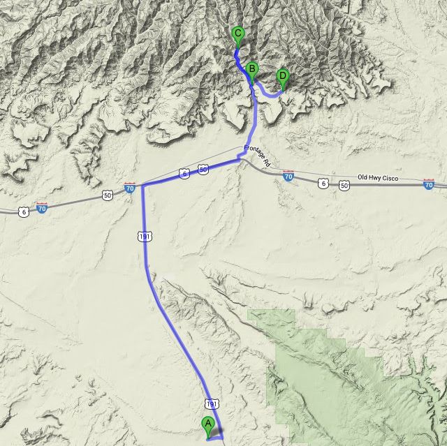
Journey map

Approximately:
- from Canyonlands Field (A) to Sego Canyon Petroglyphs (B): 25 miles and 35' drive on road
- from Sego Canyon Petroglyphs (B) to Sego Ghost Town (C): 3 miles and 10' drive on dirt road
- from Sego Ghost Town (C) to Half Moon Arch (D): 4 miles and 15' drive on dirt road
J34 - Wednesday, June 13 (continued)
After this superb flight, we must return to reality more "down to earth" ![]() and we hit the road for Sego Canyon where we arrive at 1:28 pm with 88 °F, after crossing Thomson,
not a ghost town but not far (39 inhabitants at the 2010 census)..
and we hit the road for Sego Canyon where we arrive at 1:28 pm with 88 °F, after crossing Thomson,
not a ghost town but not far (39 inhabitants at the 2010 census)..
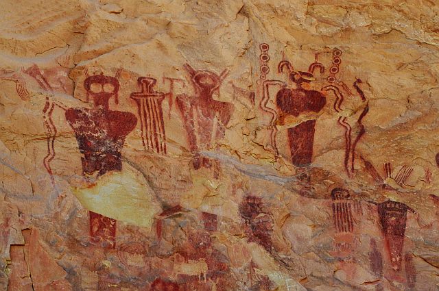
In the canyon there is, in the opinion of experts, three types of pictographs / petroglyphs from different eras
and quite easily identifiable, marked with a panel of BLM (I see four different but am not a specialist type):
- Barrier Canyon: about 6000 years until the beginning of our era (6000 B.C. - 100 B.C.), nomadic hunter-gatherers. It consists of anthropomorphic kind, deep or absent eyes and often without members; we will see soon some of them in Horseshoe Canyon;
- Fremont Indian: from 600 to 1250 (600 A.D. - 1250 A.D.). Contemporary of Anasazi (Four Corners) or Pueblos (Mesa Verde), representation of body often trapezoidal and many animals. We'll see later some of them in 9 Mile Canyon;
- Ute Indian: from 1300 à 1880 (1300 A.D. - 1880 A.D.), clearly identifiable by the presence of horses, so post-Columbus.
This place is the most accessible of the Moab area to observe petroglyphs. The main panels are on the left side of the road
when coming, but we found others, almost opposite, unfortunately with much more recent writing and some ones in a corral; a small
arch (Sego Canyon Arch) also on the right , easy to find.
We take pictures petroglyphs right and left of the road, then lunch in the wash, practically under the petroglyphs Barrier type
in the little shade we can find at this hour.
Sego Canyon Petroglyphs (23 photos)
We leave this place at 3:10 pm with 90°F and the road has now becomes track but no problem to ride. We go back a little Thomsom Canyon,
then Sego Canyon and immediately turn right a very passable track (BLM332, to Sagers Canyon), looking for Half Moon Arch.
We park the car and leave at 4:20, a bit random, not having much data on this little arch except one GPS point. Descent into a wash, change,
ascent, descent and finally turn back because we can not continue, a step is far too high for us (several yards).
We go up the wash to the track, but we don't find the arch, too bad, the ride was nice and pedometer indicates 0.72 mile.
Back in Sego Canyon to the ghost town, remainders of a coal mining between 1910 and 1945; in fact, not a town, but some ruins of buildings
whose main store (General Store) and hotel (Boarding House), collapsed between October 2009 and April 2010.
The photo of hotel before its collapse is copyrighted: Moabdave.
We find shade under a big cottonwood and we settle for the night. Drink, fire, dinner and sleep at 9:15 pm
I discovered by writing this page that Sego Canyon, beyond petroglyphs, was private property, so be respectful as usual ![]() .
.
Sego Canyon &surroundings (15 photos)
J35 - Thursday, June 14
Wake up at 6:30 am, the sky is clear, cloudless. We leave at 7:57 to Green River with already 70°F, but still take some pictures of pictographs on the way, these latter being now in full sun.
Sego Canyon Pictographs in the morning (2 photos)


