JavaScript is not enabled.
Needed to see the photo galleries.
Horseshoe Canyon
![]() version française
version française
Pictures are small in size and grouped in gallery; just a click on it and you'll have all the gallery in bigger size!
Easy navigation with left or right arrow on the keyboard; leaving the gallery photo by Escape.
Do not forget to switch to full screen (F11). Javascript is required.
Journey map
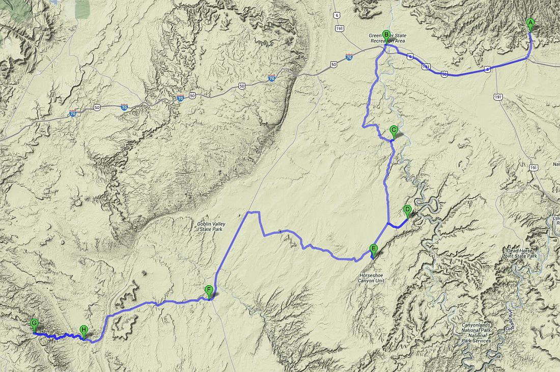
Approximately:
- from Sego Canyon (A) to Green River (UT) (B): 31 miles and 0h40 drive on road
- from Green River (B) to Chaffin Ranch (C): 23 miles and 1h30 on dirt road
- from Chaffin Ranch (C) to Colonnade Arch (D): 20 miles and 1h20 on dirt road
- from Colonnade Arch (D) to Horseshoe Canyon (E): 11 miles and 0h45 on dirt road
- from Horseshoe Canyon (E) to Hanksville (F): 47 miles and 2h20 on dirt road/paved road
- from Hanksville (F) to Fruita (G): 38 miles and 0h50 drive on road
J35 - Thursday, June 14 (continued)
We arrive at Green River at 8:47am, locate a grocery store for our next visit in a few days and reserve a room for the night of 20 June at Rober's Roost Motel.
We leave Green River at 9:14 (in fact, it's rather a one-horse town than a town, that had to have its moment of glory, there are full of shops to be sold),
first towards the airport and on the left, the Lower San Rafael Rd which will be our main focus during the next 36h.
A few photo stops along the track, especially near Horse Bench Reservoir with beautiful geological layers offered to us.
A brief detour to Fossil Point but we prefer finally leave without seeing anything spectacular.
Photo stop at Dry Lake Meander along the track; it's a former meander of the Green River dated about 2 million years.
A small path on the left leads to Chaffin Ranch, along the San Rafael River, where a geyser should, in principle, spitting every 20 minutes;
it's 10:30 am with 82°F on thermometer.
The ground is still wet, indicating a "blowout" fairly recent but we'll wait one hour, nothing. Too bad, we leave at 11:37.

Chaffin Ranch (17 photos)
Second track on the left and, if before we could drive with a passenger car, there it's SUV mandatory: sandy and rocky are
our friends  .
.
We arrive at 12:35 pm with 86°F on parking lot of Fivehole Arch or Colonnade Arch nd we had lunch in our car because there is not a bit of shade.
At 2:14 pm, here we go to the arch. A little bit of "way finding" because our GPS points seem to be not accurate and we were trying to hike down
too early to the Green River; Isabelle finally find Crocodile Rock, funny rock formation due to erosion and finally, after we separated,
we find two different paths for Fivehole Arch where we arrive at 3:47 pm.
In addition to the arch, beautiful views of the Green River and the reddish cliffs.

Fivehole Arch - Colonnade Arch (16 photos)
We leave the arch at 4:08 pm and are back to the car at 4:52; the return is much easier and we realize (it's always easier
after ) we could just go straight to the before last GPS point, but
there is very little cairns in this area and at least two "paths" marked; the pedometer shows 4.3 miles. Isabelle wonders if
she did not catch a hot shot, the hike is entirely in sunlight and the hour propitious.
Our program planned to sleep there, but besides that it's still early, there is no shade and we decide to move closer our tomorrow hike.
We leave here at 5:10 pm and temperature continues to rise as it is now 95°F. Brief stop at Keg Knoll to search (unsuccessfully) of a small arch.
Back on the main track which now becomes more difficult (no worries still with our vehicle  ),
more corrugated and degraded, narrower.
),
more corrugated and degraded, narrower.
At a place called The Mailbox, we take the trail to the left and arrive at Horseshoe Canyon trailhead. From memory, it was forbidden to make fire
as temperature and wind were high.
Many interpretive signs tell us about tomorrow hike and make panic Isabelle: the hike will be very long (between 3h and 8h), we will take
a lot of water and more, there are bugs that can give us germs  .
.
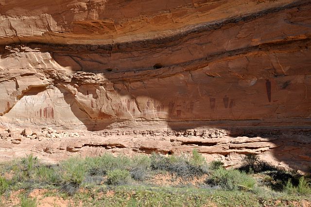
Tomorrow is the day dedicated to the visit of panels of Horseshoe Canyon or Barrier Creek (it has also given its name to the style of these pictographs). Experts estimate their age at about 6,000 years. The NPS also sets available a file (HorseshoeBook.pdf) if you want more information on this subject.
J36 - Friday, June 15
Wake up at 5:15, the day is just beginning to point but we prefer to go on a hike early because of the outside temperature. Isabelle was scratched all night; already insects?
We leave at 7am; plus our camel-bags, I carry our additional water (1 gal) and Isabelle our food. At 7:35, we pass the barrier and 9 minutes later, arrive in the wash.
The descent is easy, well marked; only the end in the sand is a little painful. Isabelle does not like, once again, walking in the sand a little soft.
Fortunately, it's early, there's shade. Then it will be a series of stops to various panels of pictographs, all but High Gallery are located on the right side of
the canyon (upbound): Horseshoe Shelter Gallery, Alcove Gallery, Great Gallery and High Gallery . At Great Gallery, a rather old ranger passes but, evidently,
with no desire to discuss, a simple hello.
The panels are, on the whole, fairly well preserved and easy to find. We are at Horseshoe Shelter Gallery at 8:07 am.

Horseshoe Shelter Gallery (14 photos)
We reach in Alcove Gallery, aptly named, at 8:30 (the panel is a bit insipid). You can't miss this alcove, huge. A barrier, symbolic, prevents approach too loan on some place (visible on the pictures).

Alcove Gallery (7 photos)
At 9:08, I arrive at Great Gallery, the pinnacle of this hike with a beautiful array of pictographs and I find Isabelle, who being behind me, found a shortcut
that we'll also take on our way back.
For those interested in current events, the history (partly true) of the film 127 hours was held close here since there is only 3.67 miles from Great Gallery to Bluejohn Canyon
but we don't want to hike 8 miles in the sand to see it (not to mention the morbid side).

Great Gallery (11 photos)
We start the way back at 9:29 am but it lacks a panel and, after a foray into Water Canyon full of cottonwoods,
we finally find it at 10:31, on the other side of the canyon with actually some cairns to indicate it.
At the same place, a beautiful female figure in the rock that some call The Guardian.

High Gallery (7 photos)
We find some shade before the rise and we begin it at 10:52 and at 11:08 we pass the barrier and arrive on the parking lot at 11:42 am.
Finding 1: 4:42 hours including breaks and not 8 hours as announced for the inexperienced, and the worst, I went back with my 8.8 lb of extra water
Finding 2: Isabelle takes a "shower" with the water I brought and which we have not touched, a little warm
.
We take again the track at 12:20 pm with 90°F on thermometer. I stop to exchange driver and then Isabelle shows me what is itching her: it looks like large patches
of hives. We ate the same thing, it should not be food. Given the location of buttons, Isabelle rather thinks a problem with cleansing powder, poorly flushed?
At 1:28 pm, we find again the road UT-24 towards Hanksville where we fill up and then we go to the BLM office for information about weather and to visit an old mill:
Wolverton Historic Mill, moved and reassembled next door. Discussion with the ranger on the weather: the next night will be hot, 99°F in the day and windy;
also focus on the next tracks we intend to: Cathedral Valley and Reds Canyon. He simply recommends us the most elementary prudence and to
buy a shovel (for digging out just in case  ).
Lunch in the car in the little shade available, with 97°F.
).
Lunch in the car in the little shade available, with 97°F.

Wolverton Historic Mill (7 photos)
We leave again at 4:08 pm with 2°F more nd try to get some pictures of Factory Butte but a huge
cloud makes us renounce. Passage through Fruita school, zapped in 2009, information again with the ranger. Then, we drive to the ford and try
to find a place to sleep as the Fruita campground is full. We find out the ford, but not to stay there (anyway it was forbidden
) because it's full of horseflies .
Small backwards step because I spotted a place to go on the right (Hanksville direction) and, bingo, it's a tiny (micro) site where you can sleep and there is
an old attic Fremont (maximum 2 or 3 cars in the parking lot).
Transfer of pictures, toilette, diner with lots of bugs but no gadflies, Isabelle is scratching a little less. A small camper pulls up near us for the night. Sleep at 8:30.

_B-10_4K_daz30_rec.jpg)
_R-10_4K_pxlr_ret.jpg)
.jpg)
_daz30.jpg)
_4K_daz30.jpg)
_R-10_4K_pxlr.jpg)
Factory Butte & Fruita Schoolhouse (12 photos)