JavaScript is not enabled.
Needed to see the photo galleries.
Dinosaur National Monument
![]() version française
version française
Pictures are small in size and grouped in gallery; just a click on it and you'll have all the gallery in bigger size!
Easy navigation with left or right arrow on the keyboard; leaving the gallery photo by Escape.
Do not forget to switch to full screen (F11). Javascript is required.
Journey map
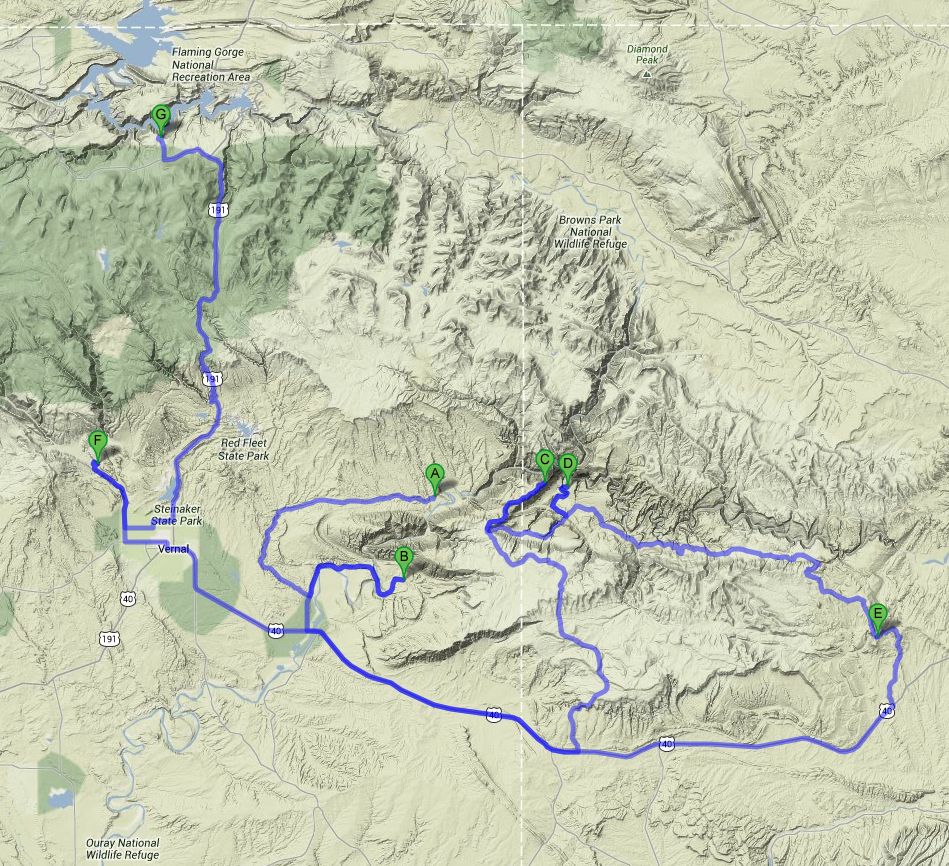
Approximately:
- from Rainbow Park (A) to Dinosaur NM - Utah (B): 32 miles and 1h20 on dirt road/road
- from Dinosaur NM - Utah (B) to Echo Park (D): 85 miles and 3h on road/dirt road
- from Echo Park (D) to Mc Conkie Ranch (F): 118 miles and 4h20 on dirt road/road
- from Mc Conkie Ranch (F) to Flaming Gorge (G): 49 miles and 1h15 on road
J43 - Friday, June 22
Wake up at 6:30, the night was cooler, pleasant. There is a beautiful sun and the sky is slightly cloudy. After breakfast, photo shoot on the edge of the river,
then we go to Island Park Overlook; a coyote crosses the road in front of us.
PTS recommends afternoon for photos but our program does not allow it.
Despite the hour  , he view is superb on this bend of the Green River and its small sandy islands.

Island Park Overlook (9 photos)
We make a u-turn and, at 8:45 am, we arrive at the small parking for Mc Kee Spring Petroglyphs of Fremont culture where we spend a quarter of an hour.
After these petroglyphs, we go join the VC of Dinosaur National Monument, Utah part. I noted two ways to go, a path along a pipeline (near Gas Pipeline Rd)
but soon proved quite rough and the other taking by Brush Creek Rd and avoiding Vernal. This is the second that we finally take.
Some nice views and a beautiful sign.

Mc Kee Spring Petroglyphs (23 photos)
Small snack with biscuits, visit of the VC, postcards and information (a ranger advises us even on the way out to take on the next day) and departure at 10:45. I have not planned the standard hikes but only the overviews and the petroglyphs.

Swelter Shelter (8 photos)
We continue with Split Mountain overlook where we find again the Green River which has cut in 2 the mountain, hence it's name.

Split Mountain (15 photos)
After crossing the Green River, the road goes along the Chew Ranch and Cub Creek before reaching the last petroglyphs of the day, the panel of "famous" lizard where a small climb in the sun (90 °F) allows us access more closely; we are practically the only ones to go up to there.

Cub Creek (31 photos)
À 13h04, nous faisons halte au Green River Campground for a picnic in the shade and we leave again at 2pm, the car thermometer indicating 93 °F.
We stop in Jensen for refueling because the next day will be largely on track, then we go towards the VC of the Colorado part of the park.
Additional information on the state of the track and the weather and we take Harper Corner Scenic Drive but we're a little disappointed with the views, probably expecting us better.

Echo Park Overlook & Harpers Corner (12 photos)
Then we begin the descent (about 800 meters) of Echo Park Rd which itself is a true track that I don't recommend with a sedan.
Beautiful and pretty descent path that leads us, through red and cream layers, to a superb panel of petroglyphs but we must look carefully
(pointillism  ) then to Whispering Cave, small crevice at the foot of a high cliff
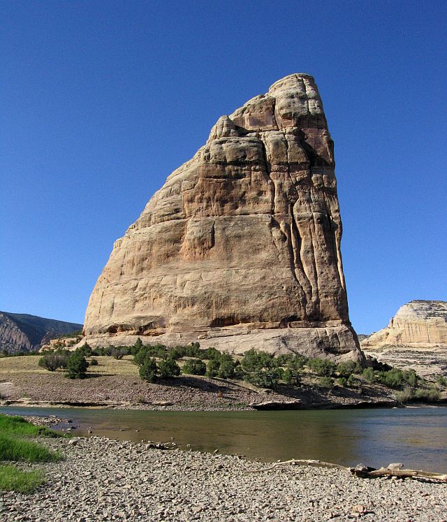
where a very cool air flows, and finally we arrive at the Echo Park campground, at the confluence of the Green River and Yampa River,
symbolized by Steamboat Rock.
) then to Whispering Cave, small crevice at the foot of a high cliff
where a very cool air flows, and finally we arrive at the Echo Park campground, at the confluence of the Green River and Yampa River,
symbolized by Steamboat Rock.
NWe quickly choose a location (6:07 pm and 95 °F) because we're far from being alone and cars continue to arrive for the night (camping first-come,
first served). Walk to the waterfront, nice foot bath in cool water, chat with a Canadian paleontologist (he wrote his thesis around here);
then lunch and sleep at 9:18 pm.

Steamboat Rock (28 photos)
J44 - Saturday, June 23
Wake up at 6:15 am, after a not very nice night, very hot. After breakfast, we go see Picasso Face, rock curiosity (seen yesterday) vaguely
resembling ;
it's at the beginning of the hike for the Steamboat Rock point of view.
No worries initially, it climbs, it slides but we go up quickly.
After that, we have to look a little. And there, sure of myself, without a map or GPS, I go almost due north and I get it wrong miserably
 .
.
Having exceeded all information distances noted, we make a u-turn, despondent, and it's when we arrive at our car (9:54 am) I discovered my mistake;
the biggest regret of this circuit. Too bad, we don't have views or photos of this overlook of the confluence of the Yampa River and Green River.
We leave again to the overlooks on the Yampa River, along the Yampa Bench Road; an SUV is mandatory.
First stop at 10.30 and 90 °F at Castle Park Overlook we find very well. Then, Harding Hole Overlook at 11am; pretty. Then Wagon Wheel Point
around 11:15 am where we'll not go to the end of the hike; the track to Haystack Rock is closed. We leave the park at noon after crossing a destroyed forest,
but there are still thirty miles to US-40 that we take in the direction of Vernal. I am still wondering if we would not have had to turn back
after Wagon Wheel Point and join Vernal via Miners Draw Rd.
We pause at the VC, Colorado side, for lunch in the shade at 12:55 pm and 91 ° F, but with a howling wind, presumably force 6 on Beaufort scale; not very convenient to eat.

Echo Park (18 photos)
Toilet then departure for Dry Fork Petroglyphs on west of Vernal, where we arrive around 4:15 pm after a nice road.
Beautiful petroglyphs on private land, easily accessible; the right side is average but it's much better on the left side.
Near the end, a scene of bear hunting but a telephoto is essential. These petroglyphs are Fremont type, but there is a bit of everything, even contemporary  .
.
Back to the car at 5:15 pm with 93 °F.

Mc Conkie Ranch (38 photos)
We then take the road to Flaming Gorge; the road winds and climbs to almost 8,500 feet and finally down through a forest of birch and conifers.
We arrive at Canyon Rim Campground at 6:30 pm and, despite the altitude, it's still 81 °F; among locations still free, we choose the 11, not too far
from the rim where we quickly take a glimpse before sunset.
The indications are not very clear: is campfire authorized or not? As soon as we see flames on another site, we start ours ,
with a good drink ; no bugs for once.

_daz30.jpg)
_4K_daz30.jpg)
Flaming Gorge (7 photos)