JavaScript is not enabled.
Needed to see the photo galleries.
Castle Gardens
![]() version française
version française
Pictures are small in size and grouped in gallery; just a click on it and you'll have all the gallery in bigger size!
Easy navigation with left or right arrow on the keyboard; leaving the gallery photo by Escape.
Do not forget to switch to full screen (F11). Javascript is required.
Journey map
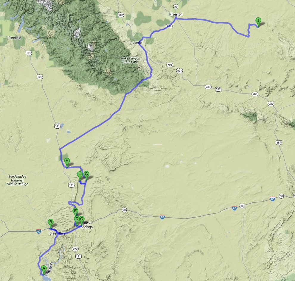
Approximately:
- from Flaming Gorge (A) to Green River - Wyoming (B): 31 miles and 0h40 on road
- from Green River (B) to White Mountain Petroglyph (F): 57 miles and 2h20 on road/dirt road
- from White Mountain Petroglyph (F) to Castel Gardens (I): 177 miles and 4h50 on road/dirt road
J46 - Monday, June 25
We wake up at 6:55 am with dense cloud cover; during breakfast, Isabelle sees a swan on the water far enough. The binoculars finally show us a pelican. On the hill in front of us,
two beautiful mules deer.
We leave for dry restrooms a little further, and then at 8:37 we hit the road with only 70 °F. After a bit of green near Vernal and Flaming Gorge, the landscape becomes gray, monotonous.
Arrived at Green River (Wyoming), we take a little to the left along the river for a few photos of The Palisades, Tollgate Rock, The Towers but the light is not great and there are few places to stop.
We stop at Walmart of Rock Springs at 9:39 for some shopping; we start again at 11am after having filled our bottles with ice cubes. We attack (that is the word)
the White Mountain Rd (Rd 53), which becomes quickly track (SUV mandatory, CC strongly discouraged) to arrive after many bends (vertigo, abstain) on the plateau with the same name.
On the plateau, the trail becomes good. The purpose of this trip is to try to find a horde of mustangs, but it will remain in the realm of the possible. Brief passing
near Pilot Butte then we continue due north along the rim, then on Rd 14 to arrive on the 191 at 12:34 pm and 90 ° F.

Pilot Butte (6 photos)
Small southbound descent and we find the Chiltons Cutoff closed; we continue south until we find a track to the left (Chiltons Rd ?) or finally go up the Rd 17 towards White Mountain Petroglyph where we park at 1pm; small walking and discovery of these petroglyphs, totally different from those seen so far. These are really engraved, incised into the rock. Experts believe they are aged from 200 to 1000 years. For the Shoshone, Arapaho and Ute people, this place is considered sacred. Unfortunately, the petroglyphs are a little bit faded.

White Mountain Petroglyph (32 photos)
Back to our car (1:57 pm) and we continue on again the track (in fact, it's spotless, even for RV), go near Boars Tusk, volcanic monolith; at times,
we see Pronghorn antelopes (Antilocapra americana), but still at quite distance.
We take our lunch (2:37 pm  ) at Eden where we find shade and tables but with the sprinkler activated
  .
We then take out our camping table and our seats from our car and lunch, our bare feet in the green grass.
.
We then take out our camping table and our seats from our car and lunch, our bare feet in the green grass.
We leave again at 3:34 pm with always 90 °F and refuel in Farson, but it's more a hamlet than a town. The sky is overcast and the dust raised by the wind (always present)
masks virtually the horizon. The road is long, long, long and almost without turning; small shower (our second) of 5 and a half drops,
so strong that I am forced to use the washer.
We arrive in South Rest Area, after crossing the Continental Divide; I had vaguely planned to spend the night in this area but it's only 4:21 pm and we decide to go further.
We go to Red Canyon where lovers of "red" should be delighted, Lander and Riverton near where we take the 136 (Gas Hills Rd).

Red Canyon (7 photos)
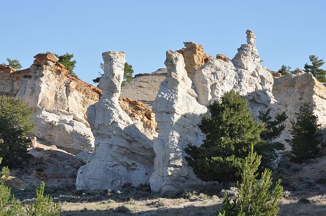
Finally, we take the track Castle Garden Rd on our left, well signposted. This track is also good, but the next (and last) section on the right a little less and I think a SUV is recommended, but a sedan is likely to pass. I had a little trouble finding information on this site, but ultimately it's well signposted. So we come to Castel Gardens at 6:35 pm, again with 90 °F.
This place presents to us two major advantages: first, rock (sandstone, MesaVerde Formation) eroded into fantastic shapes that can, with a little imagination, resemble the towers
and turrets of an old castle (of where the place name) and, secondly, petroglyphs of yet another style (Castle Gardens Shield style), dated about a thousand years and characterized
by a particular form shields. Within these shields, different and varied designs; there are even residues of colors, so mix of petroglyph-pictograph.
Walking on the site that belongs to us because we are alone; very nice, even if the overcast sky doesn't provide the perfect light to highlight the various colors.
Unfortunately, probably for reasons of vandalism, the petroglyphs are protected by a large wire mesh and photos through it are not great (the lens of Isabelle's camera passes through,
not mine); but I am obviously not the first, it's quite easy to circumvent these protections in virtually all cases.

Castel Gardens (22 photos)
A large vertical rock has a significant number of these famous shields, enough to warrant a photo gallery for itself. We spend there the rest of the afternoon, already well advanced.

Castel Gardens - The large panel (20 photos)
Aperitif and third shower of our stay, the rain is so thick that we don't even move and continue our snack chips. By cons,
if the rain becomes too heavy, we will have problems tomorrow to leave because we are further down the track.
DSleep at 9:34 pm, slightly worried anyway.
J47 - Tuesday, June 26
Wake up at 6am, with an enough hot air for the time being, no cloud in the sky, phew  , yesterday's downpour therefore not announced other.
We redo a trip to the site to enjoy the morning light; the sun highlights beautifully the white of the eroded rock.

Castel Gardens - on the morning (20 photos)
We leave the site (we could spend the day there) at 8am with 79 °F on the thermometer, not without taking a few pictures on the ridge above the site.
The track to Moneta is always good and antelopes still not decided to leave approaching .
On the way, on Chalk Hills Draw side, some beautiful badlands just near the track (on the left, going towards Moneta).

Castel Gardens - on departure (15 photos)