JavaScript is not enabled.
Needed to see the photo galleries.
On Navajo and Hopi territories
![]() version française
version française
Journey map
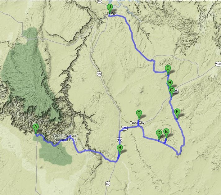
Approximately:
- from Grand Canyon Village (A) to Adeii Eechii (B) : 60 miles and 1h30 on road
- from Adeii Eechii (B) to Tuba City (C) : 28 miles and 0h40 on road
- from Tuba City (C) to Coal Mine Canyon (D) : 18 miles and 0h30 on road
- from Coal Mine Canyon (D) to Ha Ho No Geh (E) : 7 miles and 0h15 on dirt road
- from Ha Ho No Geh (E) to White & Red Canyon (F) : 33 miles and 1h30 on road/dirt road
- from White & Red Canyon (F) to White Mesa Arch (I) : 25 miles and 1h40 on dirt road
- from White Mesa Arch (I) to Page (J) : 53 miles and 1h45 on dirt road/road
J10 - Sunday, May 20 (continued)
We arrive at 8:54am at Cameron and stop at Navajo VC (almost at the intersection of Hwy 64 and 89) to buy our license to be allowed to
move our way into the reserve and camp near White Mesa Arch. According to what I have read, it's at us to fill out the form as we don't
pronounce the names the proper way. We pay $ 20 ($ 10 for the day and $ 10 for the night).
Navajo Informations
We continue with the Trading Post, forgotten in 2009. We do some shopping and we leave it at 9:58am (81 ° F) and borrow the Indian
Rd 6730 to attempt to approach a little the Adeii Eechii Cliffs; the dirt road is very rolling and we drive
in Painted Desert: it's like in the park of same name.
As hills still remaining far, we stay finally in this area, venturing off-road;  there are fragments of fossilized wood everywhere.

Adeii Eechii Cliffs (14 photos)
Back on the Hwy 89 at 11:23 and the thermometer continues to rise (84 ° F); the route crosses an area of colorful buttes, almost pink.
We then take Hwy 160 with, once again, beautiful landscapes colored with red ocher. Arrived in Tuba City, we cross it to north to see
Castle Rock, a pretty rock formation, but the track rather crosses a field of garbage.

Castle Rock (9 photos)
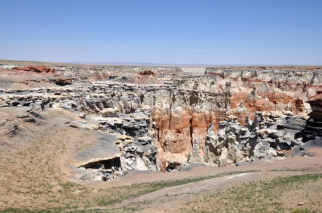
We return to Moenkopi then to Coal Mine Canyon where we arrived at 12:33pm (88 ° F). This site, on the border between Navajo
and Hopi reservations, is indicated by no sign, and to get there you have to cross a field where cows and horses graze freely: therefore,
respect the property and animals. The site's name comes from the thin layer of coal that can be clearly seen in place.
Very nice site where we take a walk with direct sunlight to admire this landscapes
with so beautiful colors.

Coal Mine Canyon (17 photos)
Then, we continue with Ha Ho No Geh Canyon, a tributary of Moenkopi Wash as Coal Mine Canyon. The dirt road begins with a long
descent and, soon enough, brings us into a landscape almost identical to the previous one. By cons, here we are alone, no another
vehicle and sometimes it is better because the track is too narrow to pass each other.
Here, the color range is different again with more yellow, some gray layers clearly separated by thin red areas.

Ha Ho No Geh Canyon (18 photos)
Before resuming our journey and with a complete absence of shade, we had lunch in our car, engine running for air conditioning because
it is 90 ° F.
At 2:45pm, we leave for White & Red Canyon; it's not the real name of this canyon, and you have to search a little bit to find it.
This canyon is located on the Hopi land and the Indians are very picky about their property and require a systematic guide: see for
example
Experience Hopi
or Hopi Tours.
The track is nice, rolling and we arrive at 3:22pm. Several travellers on VF having recently recounted problems with the Hopi Indians
 (remember we are on their land and it is mandatory to have an Indian guide), I prefer
to cancel the hike to Pillars of Hercules to make only a short walk on the site where alternating layers of red and white works
wonders and is somewhat reminiscent of our visit in 2009 in Little Egypt. We find the avatar of Sedonax (see Voyageforum.com) a little
bit damaged by effects of time (the avatar, eh! )
(remember we are on their land and it is mandatory to have an Indian guide), I prefer
to cancel the hike to Pillars of Hercules to make only a short walk on the site where alternating layers of red and white works
wonders and is somewhat reminiscent of our visit in 2009 in Little Egypt. We find the avatar of Sedonax (see Voyageforum.com) a little
bit damaged by effects of time (the avatar, eh! )

White & Red Canyon (31 photos)
We go back on Hwy 160 and, after a very brief stint at Elephant Feet then refuel at Red Lake, we hit the track for White Mesa Arch; he trail is very sandy but, after some unnecessary detours, we finally arrive at our camp for the night. A short walk in a very soft sand (yet there are tire tracks!) and we come to the arch after seeing pieces of ancient pottery. The arch is not very photogenic at that moment, hence the interest to spend the night here. Lights out at 8:53pm, with 82 ° F on the thermometer.

White Mesa Arch - on evening (4 photos)
J12 - Tuesday, May 22
Wake up at 5:45am with a very slightly cloudy sky, starting hike to the arch at 5:58am. The arch is much prettier with this morning
light. Unfortunately, clouds come fast enough, quickly reducing brightness and colors.
Back to our car at 6:24am for breakfast, then a brief return to the ark just before departure.

White Mesa Arch - at dawn (15 photos)
We break camp at 7:30am (already 72 ° F), and after 10 minutes we reach the main runway (Indian Rd 6260); in places, it becomes very sandy and we switch quickly on 4WD to avoid trouble.

_ciel_6K-pxlr-Niv82-0_82-242.jpg)
-autop3i-spher-tailler(moi)_pxlr.jpg)
_R10_B-10_pxlr.jpg)
_pxlr.jpg)
_pxlr.jpg)
_pxlr_ret.jpg)
White Mesa (9 photos)
We arrived in Page around 9am and we go to Debbie's Hide A Way to confirm our reservations, but there is nobody, just a phone number, and, given our some difficulties of understanding, we prefer to avoid. So we head directly to Walmart to complete our provisions for the next few days.