JavaScript is not enabled.
Needed to see the photo galleries.
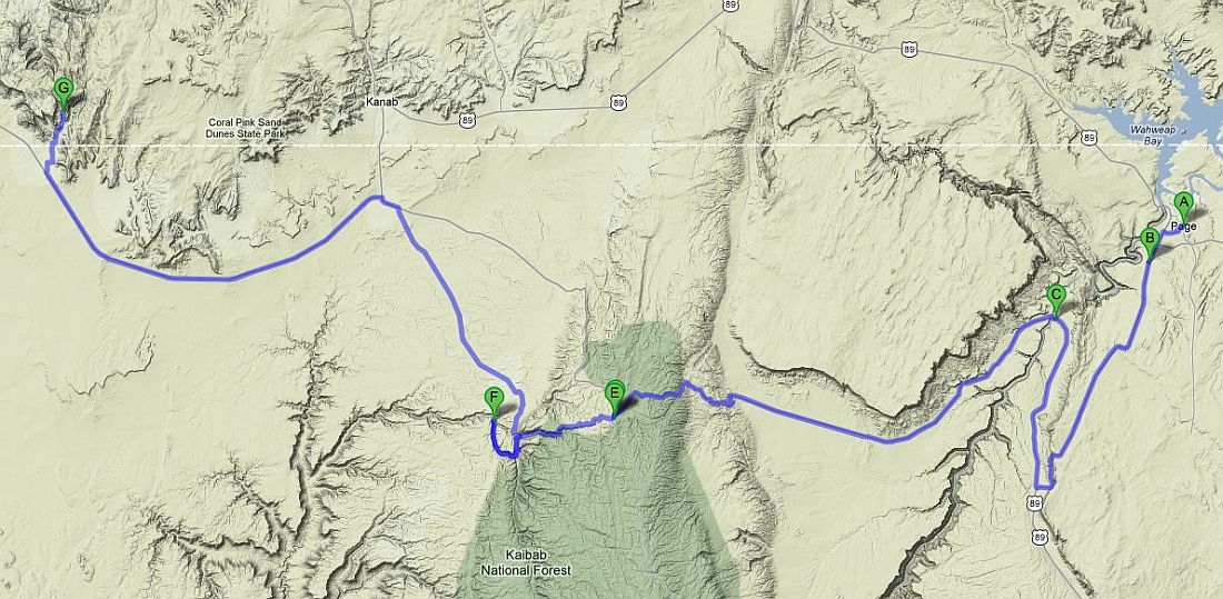
Journey map

Approximately:
- from Page (A) to Horseshoe Bend (B) : 4 miles and 0h10 on road
- from Horseshoe Bend (B) to Navajo Bridge (C) : 34 miles and 0h40 on road
- from Navajo Bridge (C) to Jacob Lake (E) : 42 miles and 1h on road
- from Jacob Lake (E) to Snake Gulch Canyon (F) : 15 miles and 1h on gravel road
- from Snake Gulch Canyon (F) to Water Canyon (G) : 64 miles and 2h on gravel road/road
J12 - Tuesday, May 22 (continued)
We leave at 10:20 towards the nearby Horseshoe Bend; we only planned a short stop (seen in 2009) but how to pass next to
it without stopping ![]() .
.
On parking lot, a small talk with our neighbors (German) that have the same vehicle as ours, but "long" version, they even tell us how to
open only the glass portion of the trunk door ![]() .
.
Hike starting at 10:25am and 88 °F, the landscape still looks beautiful and so crowded. As it's our second pass, we do not drag out and are
back to the parking lot 1h later.
We stop once again at Navajo Bridge for the restroom, the VC and to snack on a table in the shade
![]() and then set off again at 1:30pm under a blazing sun (97 °F).
and then set off again at 1:30pm under a blazing sun (97 °F).
Vermillon Cliffs (7 photos)
We stop at Jacob Lake at 2:20pm, at the beginning of the Hwy 67 to Grand Canyon north to seek the advice of rangers on the
trail we must follow because I hesitate between 2: Forest Rd 22 departing from Fredonia and another whose I don't know the name (422A),
which would be shorter.
The young ranger tells us another one, much shorter (not shown on my map), which begin almost at the beginning of the 67, near the camp
site:
461 and 462 Forest Rd. According to her, no problem with our car, no problem either with the weather, everything is nice.
![]()
We left 20 minutes later following her advice and, indeed, no problem, the track is very wide and would even be drove with a passenger car.
Pleasant stroll through the Kaibab National Forest, beautiful descent to take the FR462 and then we catch the FR 22 (partly paved)
and finally Nail Canyon.
At this time, a small trajectory error and we climb to Little Mountain and a network of tracks constantly intersecting where we
can easily lose our way. I found the route on the map so obvious that I had neglected to enter the GPS point of arrival.
Checking with our laptop and GPS coordinates, we got it wrong ![]() .
.
We make a U-turn and drive exactly on the sections followed before. A thorough reading of the map and we arrive at the end of the
canyon (cul de sac) where we'll spend the next 2 nights. Just before arrival, we meet the only vehicle that we see in the area, there is
no crowd.
It's 3:53 pm, it's 90 ° F and there is not a bit of shade apart from a small roof that houses the panels. Guess where we place ourselves?
Snake Gulch - route (5 photos)
J13 - Wednesday, May 23
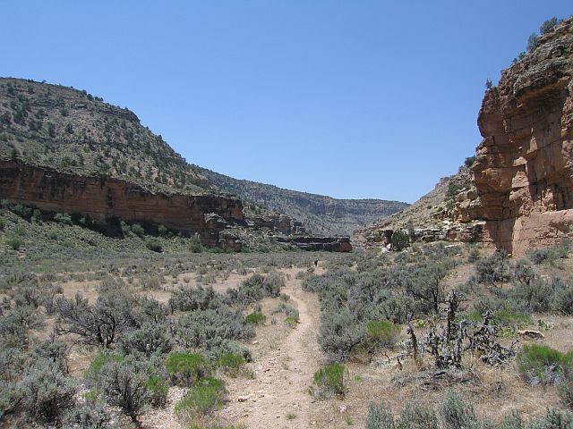
Wake up at 6:10, 63 ° F; breakfast, filling of our backpacks (water and food) and we start at 8:15am (75 ° F) for a hike in Snake Gulch Canyon; a strong wind came up. This hike is not difficult at all, almost flat at the bottom of a broad valley. Multiple photo stops for petroglyphs and pictographs pass the time pleasantly.
Snake Gulch Canyon (1) (23 photos)
I have several GPS points registered but Isabelle discovers many other cave paintings. In fact, the canyon is literally covered, just look carefully. The majority of them seem to be on the north side of the canyon, facing the sun, but we also find any on the south side, so in the shade, but more rarely.
Snake Gulch Canyon (2) (21 photos)
Snake Gulch Canyon (3) (16 photos)
Snake Gulch Canyon (4) (15 photos)
We stop for lunch at Table Rock at noon in a little bit of shade, with 6 miles on pedometer. We start our way back at 1:15pm, the wind
is very strong and strenuous, the temperature too and we finish at 3:35pm, totally knackered with 11.5 miles in the legs. Dump of our
photos on our laptop, campfire, dinner and sleep at 7:40pm ![]() .
.
Snake Gulch Canyon - on the way back (12 photos)
J14 - Thursday, May 24
Wake up at 5:30, blue sky, whistle-stop of a hummingbird ![]() .
.
Under the roof that sheltered us yesterday, there is a nest with at least three nestlings and parents go back and forth to feed them.
Several hummingbirds, one with a pink collar come visit us and a squirrel with a fat tail that comes eating within 3 feet of us, but
the camera is picked up and the slightest movement would scare everything small world
Snake Gulch (2 photos)
Starting at 7:30am (61 ° F); the view in Nail Canyon is pleasant; after 1/4h, we reach the FR22. One can drive this dirt road with a
passenger car without problems. We ascend the FR22 (or 422) to Fredonia; in front of us the spectacle of Vermilion Cliffs with, in the
background, the White Cliffs.
Towards Colorado City, we passed a sheriff's car, all lights flashing: a driver will take a fine
![]() . We quickly cross the Paiutes territory then Hildale (Colorado City), one of the most
cited Mormon communities known as polygamous. The dirt road to Water Canyon trailhead seems quite hard (sand, deep ruts) but we
find some passenger cars, like what? The small parking lot is right next to Water Canyon Reservoir. This hike was recommended to us
by Sedonax given our schedule, light enough for that day.
. We quickly cross the Paiutes territory then Hildale (Colorado City), one of the most
cited Mormon communities known as polygamous. The dirt road to Water Canyon trailhead seems quite hard (sand, deep ruts) but we
find some passenger cars, like what? The small parking lot is right next to Water Canyon Reservoir. This hike was recommended to us
by Sedonax given our schedule, light enough for that day.
Beginning of the hike at 9:50am with a pleasant temperature of 63 °F. On the right top of the cliff, a small arch
(Water Canyon arch or maybe Eye of Heaven arch)
tands out quite quickly. The trail follows the stream (little water) on its right bank, and soon the gorge narrows and then seems to
split into two forks. We try to take the left (uphill) but an American man we meet recommend caution to us and, anyway, we get away from
the axis of the canyon so obstruct the view. We therefore turn back at 11:11am. We’re back to our car at 12.05pm having traveled 2.75
miles of easy and pleasant hike.
We leave the parking lot and along the way, pass the marshal in the middle of the track and that does not pull over
![]() . Leaving Water Road, we turn right (Canyon St, cul de sac) to quickly come to a
beautiful rocky area in Vermilion Cliffs where we take a snack, almost at the entrance of a community (fairly heavy traffic) where a
tree gives us enough shade to deploy our table.
. Leaving Water Road, we turn right (Canyon St, cul de sac) to quickly come to a
beautiful rocky area in Vermilion Cliffs where we take a snack, almost at the entrance of a community (fairly heavy traffic) where a
tree gives us enough shade to deploy our table.
Water Canyon (33 photos)


