JavaScript is not enabled.
Needed to see the photo galleries.
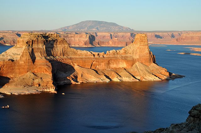
Alstrom Point
![]() version française
version française
Journey map
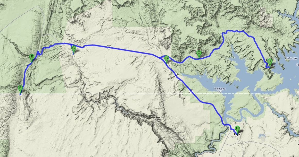
Approximately:
- from Page (A) to Big Water (B): 16 miles and 0h20 on road
- from Big Water (B) to Wiregrass (C): 8 miles and 0h30 on track
- from Wiregrass (C) to Alstrom Point (D): 17 miles and 1h30 on track
- from Alstrom Point (D) to Edmaier' Secret (E): 46 miles and 2h on track/road
- from Edmaier' Secret (E) to Stateline Campground (F): 6 miles and 0h20 on track
- from Stateline Campground (F) to Nautilus (G): 16 miles and 0h50 on track/road
- from Nautilus (G) to Page (H): 32 miles and 0h40 on road
J17 - Sunday, May 27 (continued)
Wake up at 5:40 am, breakfast, folding the freshly washed laundry, emails, loading the car; we left our home at 10am (68 °F). Refueling
and we go to Big Water to see Skyline Rental, our rental boat, where we arrive at 10:32.
After considering a rental (5 days) taking the boat to the marina (approximately $ 600 per day depending on the type of boat desired, for
us a 24' cabin to sleep inside), I looked outside Lake and prices are more affordable.
The downside is you have to drive a car with a trailer and put the boat in the water yourself. As I have a Zodiac, it's not a problem for me
 .
.
After checking our issue, validation of all points, we leave at 12:50 pm for the VC where we make inquiries about weather for the
coming days (beautiful for several days) and the state of neighboring tracks (NTR). We lunch on a table in the shade of bowers of VC.
Departure at 2:03 pm for Wiregrass (72 °F) on the trail to Alstrom Point (Recreation Rd 220 or Smokey Mountain Rd) where we arrive
at 2:20 (75 °F). Small parking lot on the right of track and we begin the short hike into the canyon at 2:40 pm. The rock is all whitish
and the hike very pleasant, very "playful", under the protection of Donald Duck .
Sometimes we hesitate: let glide down and risk a problem on the way back! But generally, the difficulty is passable and I do not need to
push the rope out of my backpack (rope of 11 yards, still in case). At worst, there is always a route to "overflow" to avoid trouble (look
for cairns). We reach the bridge at 3:25 pm; this natural bridge is formed between Wiregrass Canyon and the parallel canyon.
Backtrack by the same route and we're back at the car at 3:50 pm, the hike is only 1.5 miles.
Hike without problem, even with children.
We leave for Spencer Coal Mine, nearby on Crosby Canyon Road. Due to lack of information and observation, we go down the
road (track) to Lake Powell in very pleasant surroundings; U-turn before reaching the lake and finally we discover the three entrances of
the mine (walled up) almost at the beginning of the road. Not much to see, apart from the stacks of geological layers.

Wiregrass (44 photos)
We leave for Alstrom Point, tried in 2009 (see our website) and come again by the place where our radiator had "smoked". We
continue the trail and there, the 4WD is essential: we went on the farthest place with a standard vehicle.
We find a location perfect to spend the night and wait for sunset; it is 6:15 pm with 72 °F. What a pleasure to watch these magnificent
landscapes.
The sunset over the lake is to our expectations: simply beautiful! No need for a string of superlatives. What is nice is to watch the light
change and the shadows lengthen over the course of the sun.
After many pictures hopefully successful because it is difficult to cover all this vastness, we return to our car for the night; it is 9:05
pm and the wind is ever present and powerful.

Alstrom Point - Sunset (24 photos)
J18 - Monday, May 28
Wake up at 5:20 am, no clouds, no wind . We're alone on the roof of the world.
New photo shoot while exploring a little more the surroundings and we leave, almost reluctantly, this place from where we overlook
Gunsight Bay; it is 7:35 and the thermometer shows us 61 °F.

Alstrom Point - Sunrise (13 photos)
Half an hour later (28 minutes exactly), we have covered only 1.9 miles; that shows the track conditions
 on its last part. At the end of the descent, we turn to
the right (not the reverse) to go a little closer to what should be Moon Butte and known to us as simply Monte Negro. What
a pleasure to ride in the heart of the beautiful scenery.
on its last part. At the end of the descent, we turn to
the right (not the reverse) to go a little closer to what should be Moon Butte and known to us as simply Monte Negro. What
a pleasure to ride in the heart of the beautiful scenery.
We then head back to the VC for fresh news on weather and conditions of House Rock Valley Rd.

Moon Butte (18 photos)
Arrived at the Visitor Center at 9:25 (66 °F), the weather is still good for the rangers. So we leave at 9:48, confident, take the
House Rock Valley Road. This road (rather a track) serving, among other places, The Wave and Wire Pass,
but we stopped on the (first) parking lot to go to admire Edmaier's Secret.
Start of the hike at 10:55 after taking our permit ($ 6 each), the trail is flat and follows what must be the beginning of
Buckskin Gulch; 0.6 mile farther, we pass The Gap to reach the area of our interest . Small walk in the sun in
very soft sand and we begin to climb rocks. Then, according to our desires, we hike in this beautiful landscape (I think we
could spend the day here with no problem). Everywhere our eyes look for, it is only nipple, wrinkling, fins, all with splendid colors.
Around 12:30 pm, as our stomachs complain, we stop but could not find any shade, so it's in direct sunlight that we eat on the run.
We leave again half an hour later, find a "small wave" and take our way back.
We arrive at our car at 2:45 pm with 5.4 miles on pedometer.

Edmaier's Secret (57 photos)
Start at 3:04 pm and we continue down trail due south to find a small panel of petroglyphs that Sedonax nicknamed The Maze because of its design.
With some elements in our possession (I will not say more
), we try to find our way and an adequate parking.
We put our backpacks and go with 77 °F. Small climb and then, by feeling, we cross the plateau among the sage bushes to reach the rocky barrier
(boundary west of The Wave). Shortly before arriving there, Isabelle tells me see something and, indeed, we find it .
We're back to our car at 4:22, so it was a small hike of 40 minutes and 1.25 miles.

The Maze (16 photos)
We leave for not very far north this time, for State Line campground, on the Arizona-Utah border. The camp is not full,
but it will not be the case later. We can therefore choose our location, the main criterion being a flat place for not having our
bed too inclined. This camp is a first-come, first-served campground with campsites, a pit toilet, interpretive signs, fire rings,
picnic tables and is very nice; it's also the beginning of the Arizona trail. Each location has a small bower with a table and fire rings next to.
We transfer our photos in the PC, pass our car in the night position and admire the nice sunset on site; dinner and bedtime at 8 pm.
J19-Tuesday, May 29
Wake up at 5:45 am and departure at 7:45 (63 °F) for Nautilus. We reach Hwy 89 and then move near the ranger station (disused now?
There is no more American flag) and we take the track along the Paria River (White House Trailhead Rd). Stop just before the campground,
there is a little place to park.
We start the hike at 8:44 am (68 °F), which is completely flat and not too sandy. A barrier to cross and we quickly arrive on zone. This is
actually not common at all and we take pleasure to walk and photograph. It's a spiral slot which goes through a fossilized sand dune (Page Sandstone).
We're back to car at 9:16 am with only 1 mile on pedometer.

_daz.jpg)
_4K_daz.jpg)
_daz50.jpg)
_4K_daz30.jpg)
_pxlr.jpg)
_4K_pxlr.jpg)
_4K_daz30.jpg)
_4K_daz30.jpg)
_4K_daz30.jpg)
_R-10.jpg)
_pxlr_ret.jpg)
_R-10_pxlr.jpg)
Nautilus (19 photos)
We then go to Wal-Mart and Safeway at Page to stock up on supplies for the next 5 days on Lake Powell.