
Catstair Canyon, Toadstool Hoodoos,
White Rocks,
Wire Pass & Buckskin Gulch
![]() version française
version française
Pictures are small in size and grouped in gallery; just a click on it and you'll have all the gallery in bigger size!
Easy navigation with left or right arrow on the keyboard; leaving the gallery photo by Escape.
Do not forget to switch to full screen (F11). Javascript is required.
Journey map

Approximately:
- from Paria Outpost (A ou G) to Catstair Canyon (B): 3 mile and 4 mn drive on road
- from Catstair Canyon (B) to Toadstool Hoodoos (C): 5 miles and 5 mn drive on road
- from Toadstool Hoodoos (C) to White Rocks (D): 10 miles and 20 mn drive on road/dirt road
- from White Rocks (D) to Page (E): 26 miles and 41 mn drive on road
- from Page (E) to Wahweap Marina (F): 7 miles and 15 mn drive on road
- from Wahweap Marina (F) to Paria Outpost (A ou G): 29 miles and 38 mn drive on road
- from Paria Outpost (A ou G) to Wire Pass (H): 12 miles and 40 mn drive on road/dirt road
Tuesday, June 9
As we changed our program and being on the spot, why not try again the lottery for The Wave? 
We leave at 8am for the ranger's office where we arrive very quickly, there are only three cars and the fence is not open before 8:30.
The slim hope that could germinate in light of the few vehicles present dissipates quickly as and when the arrival of these. We'll be eventually 36 draw applicants,
for how many people (50, 60,...?), (each participant playing for his whole team), and only 10 places!
A young French couple, Vanessa and Mickaël, seems to have some difficulty understanding the concept and we talk a little bit with them.
Then, drums rolling
(no, kidding  !). But when the ranger asks everyone to stay quiet, no word and one can feel the stress rising in the gathering.
First ball, second ball ... last ball: it's still missed for us  .
.

Paria Station (3 photos)
Mickael and Vanessa had more luck than us and hold the famous Sesame: we wish them a beautiful hike.
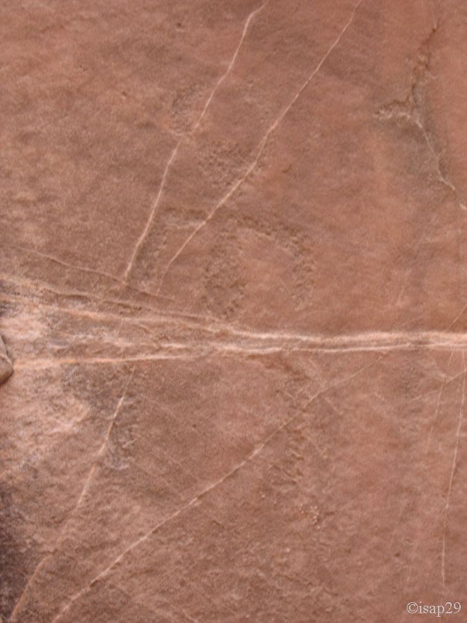
At 9:55, we go with a little melancholy for Catstair Canyon and its petroglyphs, located nearby. A very short walk (barely 10 minutes) and we enter the canyon.
We hike the whole canyon (incidentally pretty), but it only when we get out that we find petroglyphs and pictographs (there are indeed both). Many representations of
animals (Bighorn sheep, turkey, deer, snake), humans and even a jumper. The oldest are older than 6000 years;
for more information, follow this link.
In the following pictures, we have voluntarily changed some colors to better bring out the motif (such as the third below).

.jpg)
_ajust.jpg)
Catstair Canyon (22 photos)
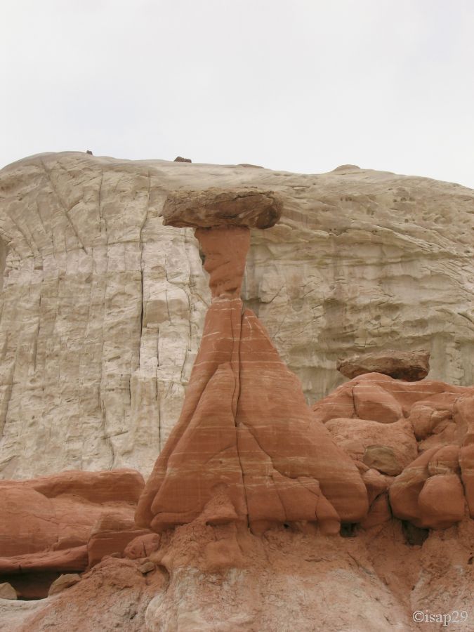
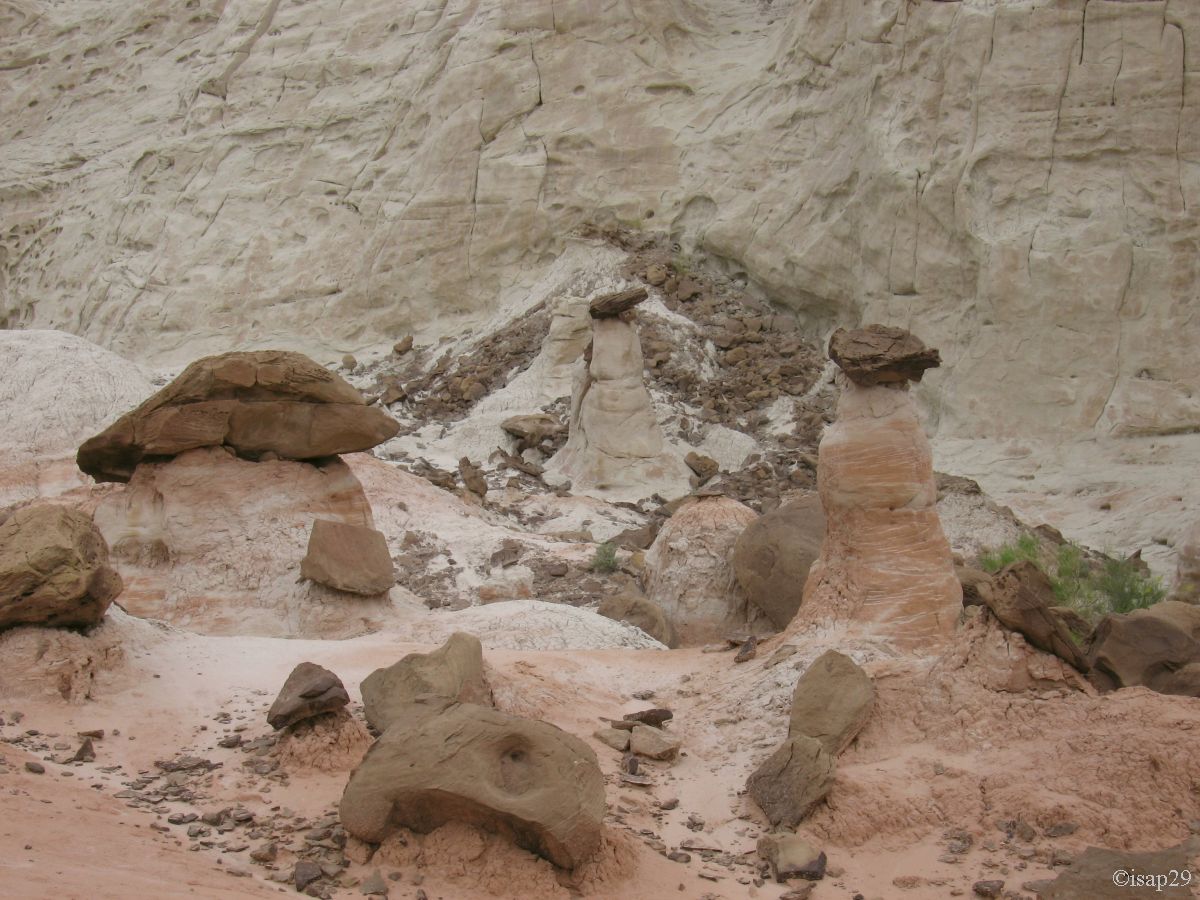
We leave Catstair for Toadstoll Hoodoos formation, a little further to east and we start the hike at 11:40.
The formation of these hoodoos is the same kind as that of Wahweap, only the color changes (the type of hat too).
The walk would be nice if there was no rain that forces us to wear the k-ways.
After a small walk in the river bed (wash), we arrive quickly at the first event: a red layer between two white layers and some monoliths with hat-like tops.
A little further on, the red hoodoos become white, but are very different from Wahweap, although geologically speaking, they are identical (millions of years can be separated).
At the end of the gorge, we see the next valley, with its alternating red and white

 - 2 images_autop-spher-liens-LV-centre-recti-tailler(moi)_B-10.jpg)
Toadstool Hoodoos (10 photos)
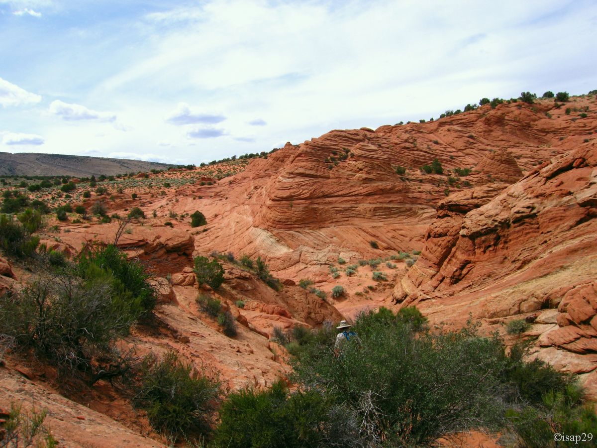
We leave at 1pm for the White Rocks that we reach with an easy dirt road, but fortunately it's not raining.
Quick snack in the middle of this landscape and ride (especially by car) in these torn formations, but not feel as much interest as the day before, at Wahweap Hoodoos.
We find again the coal seam saw yesterday, almost at the top of the plateau.

White Rocks (19 photos)
Around 3:10 pm, we're back on the US89 and decide to go to Page for some laundry and shopping. We stop at the VC of Big Water to request information
on the state of the track to Alstrom Point, but the ranger asks us to board the next day because its status may vary from day to day, depending on the
weather and he can't commit.
On the road, we stop to see the Lake Powell, near Wahweap Marina.
In Page, we rediscover traffic lights; we had forgotten what it was like!
On the way back, we stop at the dam for some pictures and then back on the road along the lake (the Pass allows us to access it).
Even if the dam is criticized, it must be said that the show is wonderful.

Lake Powell (19 photos)
We then try to reach the Dodson with our phone but always fall on an answering machine and the torrent of words of Susan does that I understand nothing about anything,
it seems to give another phone number to call, but impossible to understand everything!
We are trying to join Laurence and JP in Thousand Oaks, but Laurence says she don't understand the Martian (the link must be very bad). Too bad,
we return to Paria Outpost and then again person. And no network.
Isabelle, who was persuaded to take a shower, is a little bit annoyed but hey, we'll spend another night on their courtyard.
As we had booked for 3 nights, we sit on tables and chairs in the covered porch (I install a laundry line) and use a barbecue.
After dinner, having found an outlet for our laptop, we begin unloading and sorting the cards and pictures and there ... Aie Aie Aie,... big
disaster: Vista bug or not, we lose all our photos of the laptop
 . Fortunately, we have a backup on an external drive, but obviously not everything was saved and
the last 6 days of photos have disappeared, including those of Bryce Canyon. Isabelle is shocked and will have trouble falling asleep.
. Fortunately, we have a backup on an external drive, but obviously not everything was saved and
the last 6 days of photos have disappeared, including those of Bryce Canyon. Isabelle is shocked and will have trouble falling asleep.
Having a few (small) knowledge in the field, I decided to change the partition on the hard drive to try to recover the pictures on our return; in which case,
you must actually avoid rewriting on old data. We also put aside the memory cards of our cameras (we have enough); even formatted, it may be possible to recover something.
[We do have recovered all the photos of our laptop except the last day (Cottonwood Canyon Road) but also recovered the contents of cards from the camera to Isabelle (Compact Flash).
By cons, nothing to do for my cards (XD card).]
At 11:30 pm, we go to bed disappointed and piqued. But that's not all: just as the light is off, Isabelle hears a kind of rustle at her pillow; her sleeping bag begins to itch her
all over. It's not possible; this does not stop trouble tonight! Time to find the torch and light, we discover a huge caterpillar, banded with stinging hairs. Some of them lying on the pillow and cause a few buttons.
We give freedom to our visitor and try to get some rest.
Wednesday, June 10
Wake up at 6:50; after breakfast and morning ablutions, I write a note to Steve and Susan when, suddenly, they arrive. Some explanations with them
and apparently they have not received our last mail. Susan makes us coffee and quickly prepares our room where we'll spend two nights.
We go to the ranger station to check status of track to Wire Pass and weather for the day. Everything is ok, the rangers recommend us only to
check the sky at the confluence of Buckskin Gulch to avoid flash-flood.
The track is correct (just a little bit bumpy), we arrive at 10:25 on the parking lot and the outdoor temperature is 68°F.
After the usual ritual (walking shoes, sunscreen, backpacks), we sign the register at the trailhead and begin hiking at 10:42. After 10 minutes,
I notice that Isabelle doesn't take pictures, always within the scope of the loss of yesterday, but fortunately
it doesn't last.
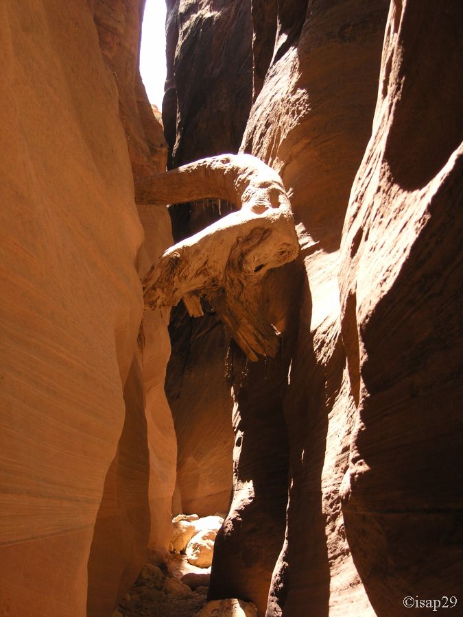
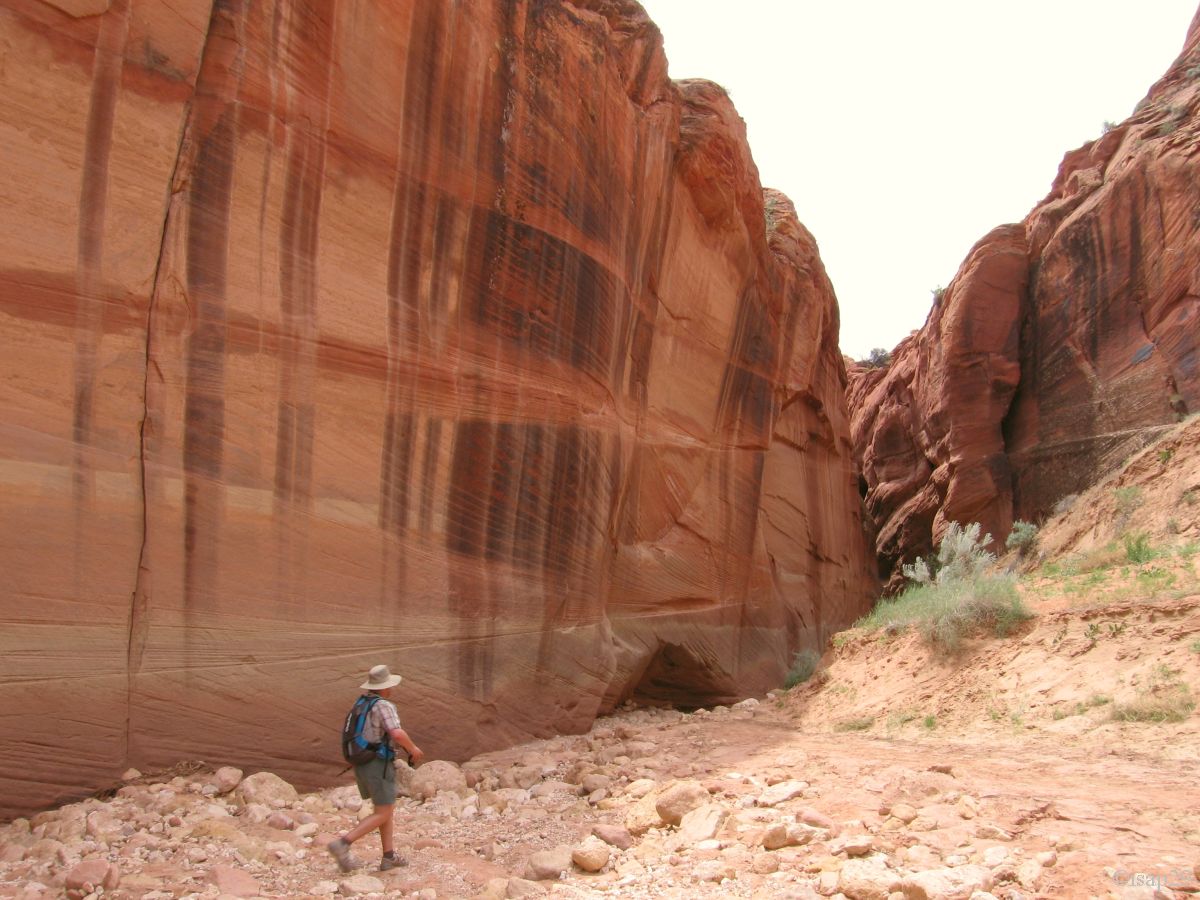
The hike (it will be the same all day) follows the wash, a little sandy, in red rock surroundings with a blue sky, almost cloudless.
Half an hour later, we arrive in the first part of this slot canyon and hear French voices in front of us.
First obstacle, a large rock blocks the canyon and we must pass on top of it; a couple of French gives up, but Isabelle shows them (especially to the woman)
that this doesn't pose major problems and they agree to continue.
This will be the only real obstacle of this hike. Two other French men, whose Gillou02 from VoyageForum are there and will continue most of the hike with us.
A first piece of wood stuck high in the wall shows how high the stream can go up on flash-floods and it's not good to be here at that time.
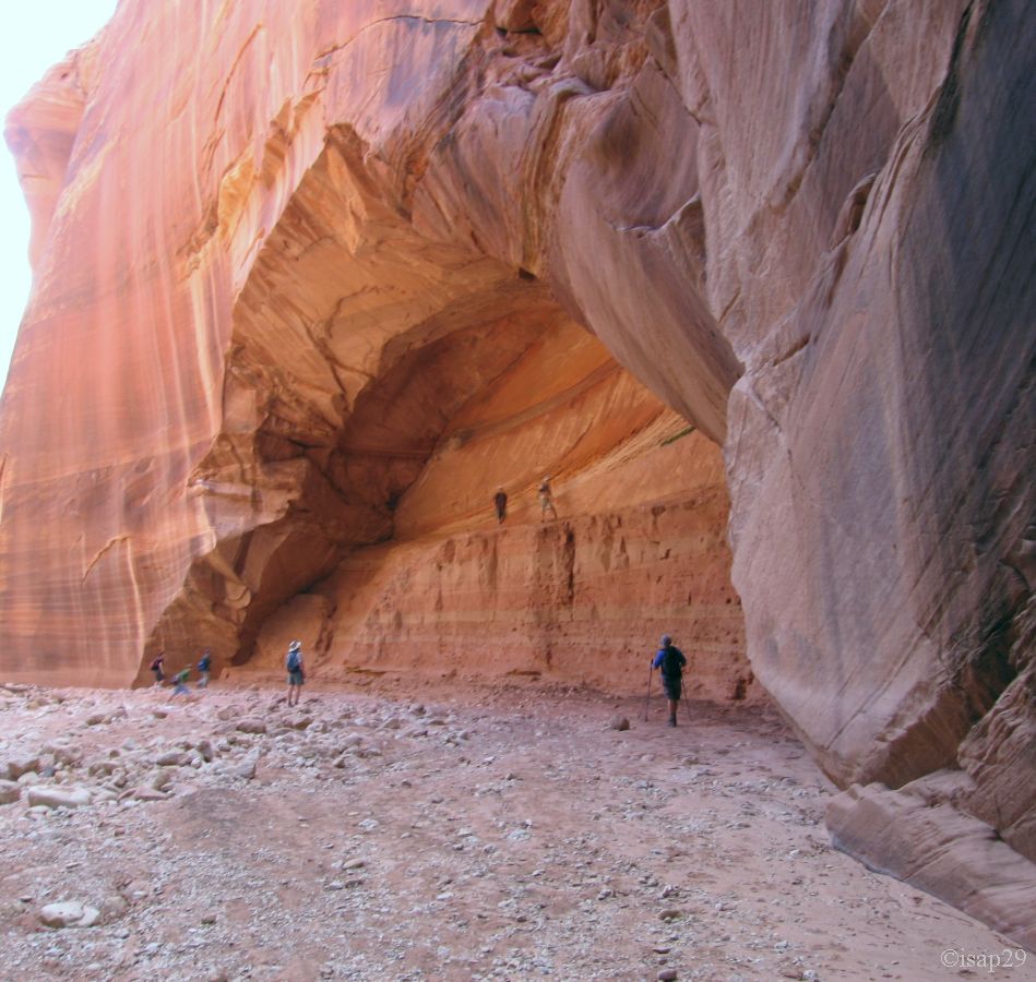
We come out of this first part (Wire Pass) by finding again the blue sky. On the right of the exit, a large alcove opens its arms;
some teens ride as high as possible, with a lot of screaming!

Wire Pass (18 photos)
The petroglyphs, just on left of the alcove, represent mostly animals and some anthropomorphic figures.

_R-10.jpg)
Wire Pass Petroglyphs (9 photos)
It's noon and we are at the confluence of Wire Pass and Buckskin Gulch. We see on our right the second part of our hike (Buckskin Gulch),
it seems very narrow (slot!) and much higher than Wire Pass and very dark. We continue in Buckskin Gulch downstream but first, as directed
by the rangers, we check the condition of the sky because once engaged in this canyon, you cannot get out before long. The sky is clear enough, we can continue.
One of our goals is to check the possibility to get out of the canyon when it goes to the east and to reach the North Teepees.
Philippe, with whom I spoke, expressed doubts but will try the same thing.
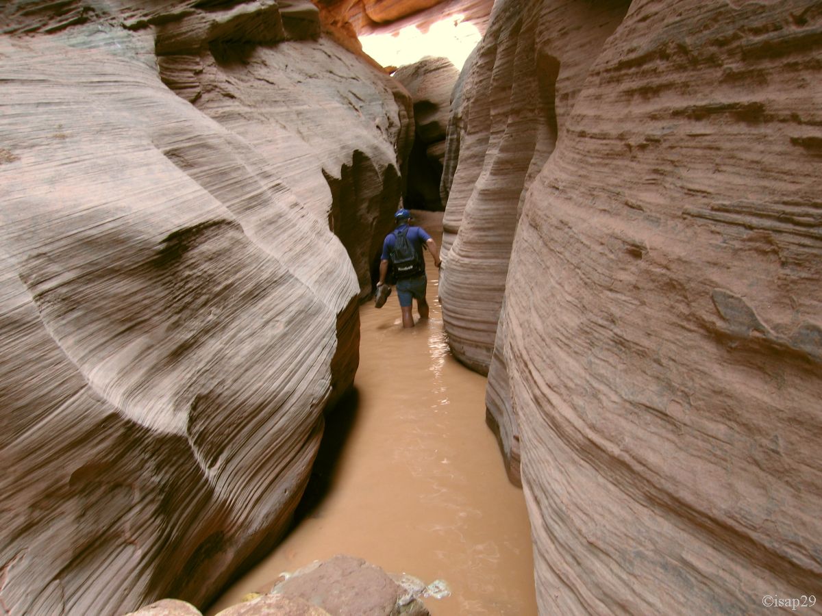
The ride is pleasant enough, the temperature is cool because of the high cliffs and we (six French) walk along the wash.
Suddenly, a first puddle appears, too large and too deep to leap over. We remove shoes and socks, cross the puddle (water is cold),
wipe our feet, put socks and shoes, and here we go again ... towards the next puddle.
The same applies at the next puddle, and so forth to fed up (after the sixth), we'll cross the followings without taking our shoes off.
Some puddles are so deep that water comes above our knees. It's here that the couple we have convinced to continue at the previous difficulty in Wire Pass left us.
Other logs planted in the walls indicate the height and violence of sudden floods.
We arrive at the place where I hope to get out, but we have to face facts (the rangers had warned me), unless to be a mountaineer, it's not possible.
[In subsequent correspondence, Philippe told me that he happened to pass the obstacles from the beginning, but eventually give up to an overhang.]
We continue with Gillou02 and his friend in an easterly direction in this beautiful canyon, a few meters wide, the cliffs between 20 and 30 m high and what colors!
I was careful not to tell Isabelle that there could be rattlesnakes but the latest storms (in light of the recent puddles) have cleaned the place up!
Two hours and 10 minutes after leaving the junction, we decide to make U- turn while Gillou02 continues a little bit.
At 3:15 pm, we're back at the junction and make the break snacks, it's time; we're soon joined by our two friends!

Buckskin Gulch (28 photos)
We leave half an hour later and, at the entrance to Wire Pass, we begin a small path on the left that seems going to the plateau, but eventually goes down a little further.
We're back in the wash and go back to our car in less than an hour, after passing the entrance to the trail for The Wave; we walked almost 10 miles
in these two magnificent canyons, and even if we don't found the expected output, it was a wonderful day.
On the parking lot, we find again Vanessa and Mickaël who arrive, happy to have hiked The Wave; we can understand them
.
Gillou02 and his friend joined us later, they had taken a wrong path.

Buckskin Gulch - way back (7 photos)
We leave the parking lot at 5:30 pm and, as Catstair Canyon is on our way, we stop to recover our lost photos. As a bonus, a few additional photos (some color are voluntarily changed).

.jpg)
_ajust.jpg)
Catstair Canyon Petroglyphs (10 photos)
Back to Steve and Susan B&B shortly before 7pm; shower and dinner with a small group of Asian tourists. As usual, the portions are huge and satiated, we go to bed.
